
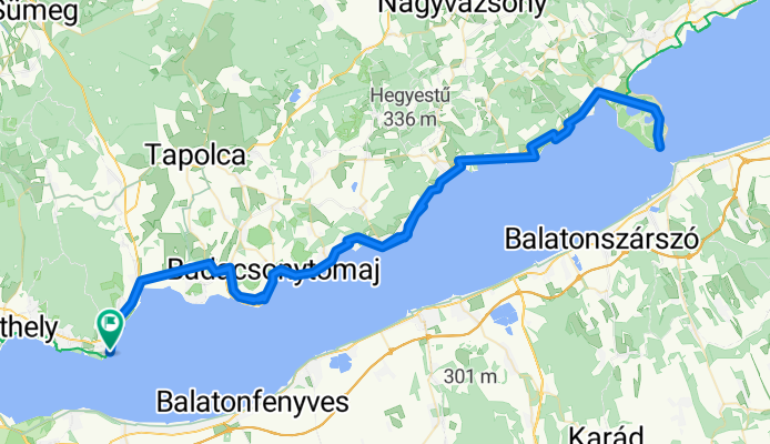
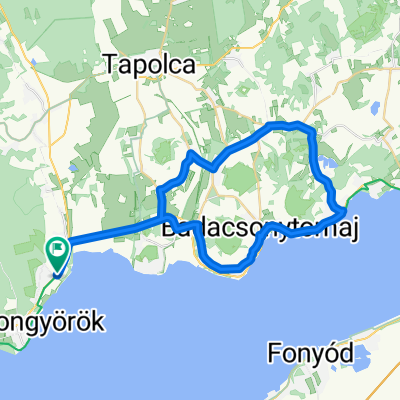
Kossuth Lajos utca, Balatongyörök - Balaton utca, Balatongyörök
A cycling route starting in Vonyarcvashegy, Zala County, Hungary.
Overview
About this route
- 6 h 59 min
- Duration
- 127.3 km
- Distance
- 843 m
- Ascent
- 845 m
- Descent
- 18.2 km/h
- Avg. speed
- 176 m
- Max. altitude

Route quality
Waytypes & surfaces along the route
Waytypes
Cycleway
63.7 km
(50 %)
Quiet road
21.6 km
(17 %)
Surfaces
Paved
123.5 km
(97 %)
Asphalt
123.5 km
(97 %)
Undefined
3.8 km
(3 %)
Continue with Bikemap
Use, edit, or download this cycling route
You would like to ride Kossuth Lajos utca, Balatongyörök - Balaton utca, Balatongyörök or customize it for your own trip? Here is what you can do with this Bikemap route:
Free features
- Save this route as favorite or in collections
- Copy & plan your own version of this route
- Split it into stages to create a multi-day tour
- Sync your route with Garmin or Wahoo
Premium features
Free trial for 3 days, or one-time payment. More about Bikemap Premium.
- Navigate this route on iOS & Android
- Export a GPX / KML file of this route
- Create your custom printout (try it for free)
- Download this route for offline navigation
Discover more Premium features.
Get Bikemap PremiumFrom our community
Other popular routes starting in Vonyarcvashegy
 Balatongyörök - Balatonszentgyörgy csapattal
- Distance
- 26.2 km
- Ascent
- 42 m
- Descent
- 16 m
- Location
- Vonyarcvashegy, Zala County, Hungary
 Kossuth Lajos utca, Balatongyörök - Balaton utca, Balatongyörök
- Distance
- 127.3 km
- Ascent
- 843 m
- Descent
- 845 m
- Location
- Vonyarcvashegy, Zala County, Hungary
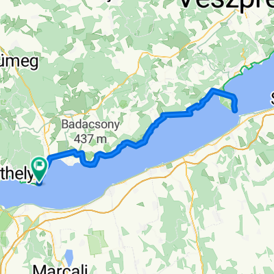
 Eresztényi út, Balatongyörök - Eresztényi út, Balatongyörök
- Distance
- 40.8 km
- Ascent
- 233 m
- Descent
- 232 m
- Location
- Vonyarcvashegy, Zala County, Hungary
 Vonyarcvashegy-Keszthely-Balatonberény és vissza, majd Balatongyörök-Szigliget-Badacsony és vissza Vonyarcvashegy
- Distance
- 75.7 km
- Ascent
- 181 m
- Descent
- 226 m
- Location
- Vonyarcvashegy, Zala County, Hungary
 Eresztényi út, Balatongyörök - Eresztényi út, Balatongyörök
- Distance
- 44.3 km
- Ascent
- 233 m
- Descent
- 232 m
- Location
- Vonyarcvashegy, Zala County, Hungary
 Balatongyörök - Balatonfüred
- Distance
- 86.1 km
- Ascent
- 428 m
- Descent
- 426 m
- Location
- Vonyarcvashegy, Zala County, Hungary
 Eresztényi út, Balatongyörök - Eresztényi út, Balatongyörök
- Distance
- 36.4 km
- Ascent
- 224 m
- Descent
- 230 m
- Location
- Vonyarcvashegy, Zala County, Hungary
 Györök - Borbarátok - Szent-György-hegy - Györök
- Distance
- 48.6 km
- Ascent
- 251 m
- Descent
- 253 m
- Location
- Vonyarcvashegy, Zala County, Hungary
Open it in the app