
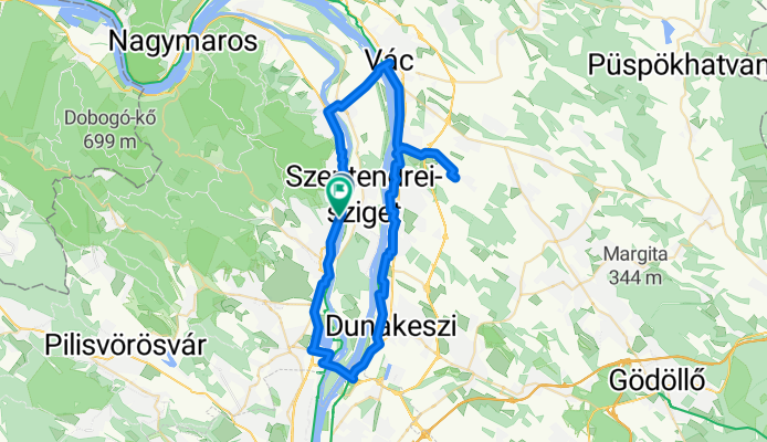
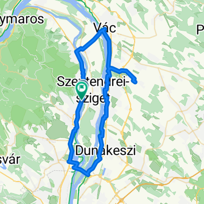
11-es főút, Leányfalu - Ady Endre utca, Szentendre
A cycling route starting in Leányfalu, Pest County, Hungary.
Overview
About this route
- 5 h 28 min
- Duration
- 59 km
- Distance
- 199 m
- Ascent
- 187 m
- Descent
- 10.8 km/h
- Avg. speed
- 123 m
- Max. altitude

Route quality
Waytypes & surfaces along the route
Waytypes
Cycleway
27.1 km
(46 %)
Quiet road
10.6 km
(18 %)
Surfaces
Paved
50.8 km
(86 %)
Unpaved
0.6 km
(1 %)
Asphalt
47.8 km
(81 %)
Concrete
3 km
(5 %)
Continue with Bikemap
Use, edit, or download this cycling route
You would like to ride 11-es főút, Leányfalu - Ady Endre utca, Szentendre or customize it for your own trip? Here is what you can do with this Bikemap route:
Free features
- Save this route as favorite or in collections
- Copy & plan your own version of this route
- Sync your route with Garmin or Wahoo
Premium features
Free trial for 3 days, or one-time payment. More about Bikemap Premium.
- Navigate this route on iOS & Android
- Export a GPX / KML file of this route
- Create your custom printout (try it for free)
- Download this route for offline navigation
Discover more Premium features.
Get Bikemap PremiumFrom our community
Other popular routes starting in Leányfalu
 Csóka utca - Monostori utca
- Distance
- 3.3 km
- Ascent
- 3 m
- Descent
- 51 m
- Location
- Leányfalu, Pest County, Hungary
 pap-rét kör visegrádon át CLONED FROM ROUTE 1487566
- Distance
- 18.1 km
- Ascent
- 670 m
- Descent
- 670 m
- Location
- Leányfalu, Pest County, Hungary
 Vanília utca - Barátság útja
- Distance
- 26.4 km
- Ascent
- 133 m
- Descent
- 312 m
- Location
- Leányfalu, Pest County, Hungary
 Dombalja utca 9, Szentendre to Dombalja utca 7, Szentendre
- Distance
- 19.8 km
- Ascent
- 600 m
- Descent
- 595 m
- Location
- Leányfalu, Pest County, Hungary
 Sztaravoda_Visegrad
- Distance
- 13.8 km
- Ascent
- 354 m
- Descent
- 408 m
- Location
- Leányfalu, Pest County, Hungary
 Unnamed Road, Dunabogdány to Fő tér 12, Szentendre
- Distance
- 11.7 km
- Ascent
- 76 m
- Descent
- 425 m
- Location
- Leányfalu, Pest County, Hungary
 11-es főút, Leányfalu - Ady Endre utca, Szentendre
- Distance
- 59 km
- Ascent
- 199 m
- Descent
- 187 m
- Location
- Leányfalu, Pest County, Hungary
 Útvonal innen: Szőlő út
- Distance
- 9.1 km
- Ascent
- 7 m
- Descent
- 52 m
- Location
- Leányfalu, Pest County, Hungary
Open it in the app