
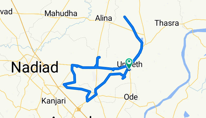
Route from M4Q7+HVa
A cycling route starting in Umreth, Gujarat, India.
Overview
About this route
- 15 h 7 min
- Duration
- 107.9 km
- Distance
- 594 m
- Ascent
- 556 m
- Descent
- 7.1 km/h
- Avg. speed
- 75 m
- Max. altitude

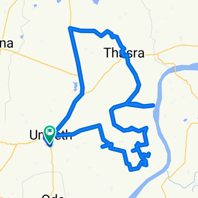
Route photos


Continue with Bikemap
Use, edit, or download this cycling route
You would like to ride Route from M4Q7+HVa or customize it for your own trip? Here is what you can do with this Bikemap route:
Free features
- Save this route as favorite or in collections
- Copy & plan your own version of this route
- Split it into stages to create a multi-day tour
- Sync your route with Garmin or Wahoo
Premium features
Free trial for 3 days, or one-time payment. More about Bikemap Premium.
- Navigate this route on iOS & Android
- Export a GPX / KML file of this route
- Create your custom printout (try it for free)
- Download this route for offline navigation
Discover more Premium features.
Get Bikemap PremiumFrom our community
Other popular routes starting in Umreth
 J3WP+PH3 to M4Q7+HV
- Distance
- 116 km
- Ascent
- 621 m
- Descent
- 586 m
- Location
- Umreth, Gujarat, India
 Gujarat State Highway to Gujarat State Highway
- Distance
- 94.7 km
- Ascent
- 366 m
- Descent
- 326 m
- Location
- Umreth, Gujarat, India
 Route to Gujarat State Highway
- Distance
- 111 km
- Ascent
- 691 m
- Descent
- 660 m
- Location
- Umreth, Gujarat, India
 Nadiad - Dakor Road to M4Q7+HV
- Distance
- 102.7 km
- Ascent
- 503 m
- Descent
- 457 m
- Location
- Umreth, Gujarat, India
 Route from M4Q7+HVa
- Distance
- 107.9 km
- Ascent
- 594 m
- Descent
- 556 m
- Location
- Umreth, Gujarat, India
 ggsbahahx
- Distance
- 177.3 km
- Ascent
- 827 m
- Descent
- 733 m
- Location
- Umreth, Gujarat, India
 M4Q7+HV to M4Q7+HV
- Distance
- 56.4 km
- Ascent
- 277 m
- Descent
- 249 m
- Location
- Umreth, Gujarat, India
 J3WP+PH3 to M4Q7+HV
- Distance
- 116 km
- Ascent
- 621 m
- Descent
- 586 m
- Location
- Umreth, Gujarat, India
Open it in the app