
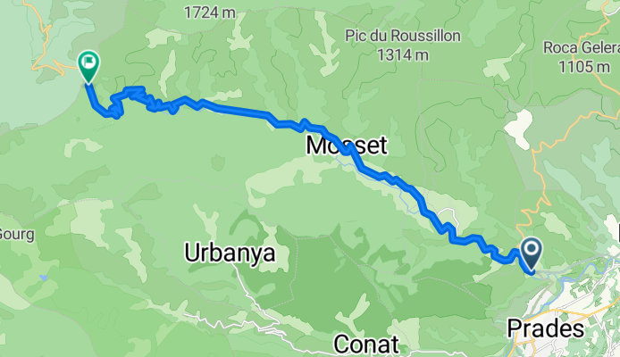
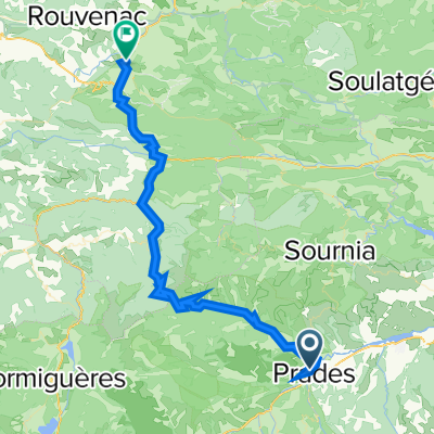
COL DE JAU (por Catllar)
A cycling route starting in Prades, Occitanie, France.
Overview
About this route
The Col de Jau (1506 m) is one of the major Pyrenean passes of the Roussillon, located in the département of Pyrénées-Orientales, linking the Têt valley and the Aude valley. It is a long, steady climb with an elevation gain of over 1,000 metres, making it a demanding ascent for both cycle-tourists and professional riders.
- 1 h 36 min
- Duration
- 22.9 km
- Distance
- 1,444 m
- Ascent
- 272 m
- Descent
- 14.3 km/h
- Avg. speed
- 1,514 m
- Max. altitude

Route photos
\"")
Continue with Bikemap
Use, edit, or download this cycling route
You would like to ride COL DE JAU (por Catllar) or customize it for your own trip? Here is what you can do with this Bikemap route:
Free features
- Save this route as favorite or in collections
- Copy & plan your own version of this route
- Sync your route with Garmin or Wahoo
Premium features
Free trial for 3 days, or one-time payment. More about Bikemap Premium.
- Navigate this route on iOS & Android
- Export a GPX / KML file of this route
- Create your custom printout (try it for free)
- Download this route for offline navigation
Discover more Premium features.
Get Bikemap PremiumFrom our community
Other popular routes starting in Prades
 Prades - Prades
- Distance
- 61.2 km
- Ascent
- 1,238 m
- Descent
- 1,237 m
- Location
- Prades, Occitanie, France
 ASCENSO AL REFUGI DE CORTALETS/ CANIGÓ (por Villerach)
- Distance
- 26 km
- Ascent
- 2,680 m
- Descent
- 877 m
- Location
- Prades, Occitanie, France
 Pyreneen - 3daagse trip
- Distance
- 188.7 km
- Ascent
- 4,116 m
- Descent
- 4,114 m
- Location
- Prades, Occitanie, France
 CtP2018 Etappe1: Prades - Col de Jau - Quillan 62km 1860Hm 4:30h
- Distance
- 61.2 km
- Ascent
- 1,473 m
- Descent
- 1,471 m
- Location
- Prades, Occitanie, France
 Tp4 prades-colliure
- Distance
- 108.3 km
- Ascent
- 992 m
- Descent
- 1,343 m
- Location
- Prades, Occitanie, France
 QV A2M S7 Prades > Argeles s Mer
- Distance
- 99.3 km
- Ascent
- 934 m
- Descent
- 1,270 m
- Location
- Prades, Occitanie, France
 ASCENSO AL REFUGI DE CORTALETS/ CANIGÓ (por Villerach)
- Distance
- 25.2 km
- Ascent
- 2,673 m
- Descent
- 835 m
- Location
- Prades, Occitanie, France
 FR Riding the Pyrenees 3.0 - Prades to Ax-les-Thermes
- Distance
- 92.1 km
- Ascent
- 2,731 m
- Descent
- 2,371 m
- Location
- Prades, Occitanie, France
Open it in the app