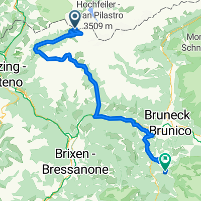
Brenner - Thal-Aue/Assling
A cycling route starting in Ried, Trentino-Alto Adige, Italy.
Overview
About this route
Im großen und ganzen dem Eisacktal und Pustertalradweg gefolgt, nur die Strecke zwischen Gossensass und Sterzing wurde (weil mir das Wetter im Nacken saß) über die Bundesstraße abgekürzt..
- -:--
- Duration
- 142.2 km
- Distance
- 601 m
- Ascent
- 1,133 m
- Descent
- ---
- Avg. speed
- ---
- Avg. speed
Route quality
Waytypes & surfaces along the route
Waytypes
Cycleway
48.6 km
(34 %)
Track
29.9 km
(21 %)
Surfaces
Paved
120.7 km
(85 %)
Unpaved
9.5 km
(7 %)
Asphalt
112.4 km
(79 %)
Paved (undefined)
6.8 km
(5 %)
Continue with Bikemap
Use, edit, or download this cycling route
You would like to ride Brenner - Thal-Aue/Assling or customize it for your own trip? Here is what you can do with this Bikemap route:
Free features
- Save this route as favorite or in collections
- Copy & plan your own version of this route
- Sync your route with Garmin or Wahoo
Premium features
Free trial for 3 days, or one-time payment. More about Bikemap Premium.
- Navigate this route on iOS & Android
- Export a GPX / KML file of this route
- Create your custom printout (try it for free)
- Download this route for offline navigation
Discover more Premium features.
Get Bikemap PremiumFrom our community
Other popular routes starting in Ried
- Tag 4. Sct. Jacob Pfitchertal - Zell am Ziller
- Distance
- 50.1 km
- Ascent
- 711 m
- Descent
- 1,679 m
- Location
- Ried, Trentino-Alto Adige, Italy
- Transalp 2011 Tag 3
- Distance
- 75.2 km
- Ascent
- 1,981 m
- Descent
- 2,021 m
- Location
- Ried, Trentino-Alto Adige, Italy
- AlpX 2013 Tag 3
- Distance
- 73.2 km
- Ascent
- 1,490 m
- Descent
- 2,844 m
- Location
- Ried, Trentino-Alto Adige, Italy
- Tag 4. Alternative Sct. Jacob - Zell am Ziller
- Distance
- 70 km
- Ascent
- 1,807 m
- Descent
- 2,786 m
- Location
- Ried, Trentino-Alto Adige, Italy
- Brenner-Drauradweg-Maribor-Wien
- Distance
- 803.5 km
- Ascent
- 12,425 m
- Descent
- 13,602 m
- Location
- Ried, Trentino-Alto Adige, Italy
- Pfitscher Joch -vintl
- Distance
- 55.8 km
- Ascent
- 1,192 m
- Descent
- 2,698 m
- Location
- Ried, Trentino-Alto Adige, Italy
- A, Tirol, Brenner - Mieders
- Distance
- 28.5 km
- Ascent
- 102 m
- Descent
- 523 m
- Location
- Ried, Trentino-Alto Adige, Italy
- day 10 alternative part 1
- Distance
- 27.6 km
- Ascent
- 958 m
- Descent
- 412 m
- Location
- Ried, Trentino-Alto Adige, Italy
Open it in the app