
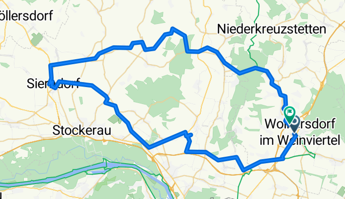
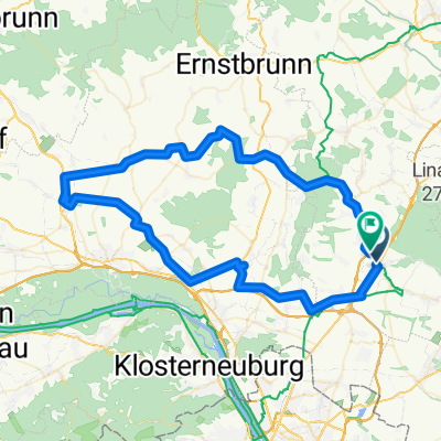
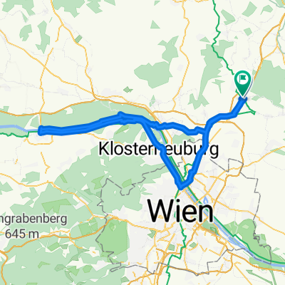
Richtung Westen bis Sierndorf
A cycling route starting in Wolkersdorf im Weinviertel, Lower Austria, Austria.
Overview
About this route
- 5 h 7 min
- Duration
- 80.8 km
- Distance
- 617 m
- Ascent
- 617 m
- Descent
- 15.8 km/h
- Avg. speed
- 319 m
- Max. altitude

Route quality
Waytypes & surfaces along the route
Waytypes
Quiet road
22.6 km
(28 %)
Track
17 km
(21 %)
Surfaces
Paved
47.6 km
(59 %)
Unpaved
12.9 km
(16 %)
Asphalt
46 km
(57 %)
Gravel
5.7 km
(7 %)
Continue with Bikemap
Use, edit, or download this cycling route
You would like to ride Richtung Westen bis Sierndorf or customize it for your own trip? Here is what you can do with this Bikemap route:
Free features
- Save this route as favorite or in collections
- Copy & plan your own version of this route
- Split it into stages to create a multi-day tour
- Sync your route with Garmin or Wahoo
Premium features
Free trial for 3 days, or one-time payment. More about Bikemap Premium.
- Navigate this route on iOS & Android
- Export a GPX / KML file of this route
- Create your custom printout (try it for free)
- Download this route for offline navigation
Discover more Premium features.
Get Bikemap PremiumFrom our community
Other popular routes starting in Wolkersdorf im Weinviertel
 Autumnable Gravel mit Wieneinfahrt.
- Distance
- 50.3 km
- Ascent
- 316 m
- Descent
- 404 m
- Location
- Wolkersdorf im Weinviertel, Lower Austria, Austria
 Wienerwaldrunde inkl. Sophienalpe
- Distance
- 95.3 km
- Ascent
- 1,345 m
- Descent
- 1,354 m
- Location
- Wolkersdorf im Weinviertel, Lower Austria, Austria
 Andl Geburtstag
- Distance
- 47.9 km
- Ascent
- 426 m
- Descent
- 383 m
- Location
- Wolkersdorf im Weinviertel, Lower Austria, Austria
 Kühltal zum Insel-Toni
- Distance
- 60.3 km
- Ascent
- 358 m
- Descent
- 403 m
- Location
- Wolkersdorf im Weinviertel, Lower Austria, Austria
 Richtung Westen bis Sierndorf
- Distance
- 80.8 km
- Ascent
- 617 m
- Descent
- 617 m
- Location
- Wolkersdorf im Weinviertel, Lower Austria, Austria
 Wolkersdorf - Energieweg Gravel - Deutsch Wagram WindGraveln - Marchfeldkanal
- Distance
- 31.4 km
- Ascent
- 107 m
- Descent
- 125 m
- Location
- Wolkersdorf im Weinviertel, Lower Austria, Austria
 Route in Wolkersdorf im Weinviertel
- Distance
- 96.2 km
- Ascent
- 474 m
- Descent
- 475 m
- Location
- Wolkersdorf im Weinviertel, Lower Austria, Austria
 Energie graveln. Sunny Side.
- Distance
- 16.7 km
- Ascent
- 117 m
- Descent
- 182 m
- Location
- Wolkersdorf im Weinviertel, Lower Austria, Austria
Open it in the app