

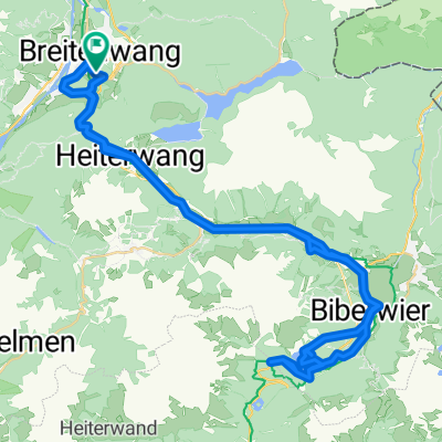
Plansee-Runde
A cycling route starting in Breitenwang, Tyrol, Austria.
Overview
About this route
- -:--
- Duration
- 92.2 km
- Distance
- 890 m
- Ascent
- 887 m
- Descent
- ---
- Avg. speed
- 1,131 m
- Max. altitude
Route quality
Waytypes & surfaces along the route
Waytypes
Road
7.4 km
(8 %)
Track
7.4 km
(8 %)
Surfaces
Paved
81.1 km
(88 %)
Unpaved
4.6 km
(5 %)
Asphalt
81.1 km
(88 %)
Loose gravel
1.8 km
(2 %)
Continue with Bikemap
Use, edit, or download this cycling route
You would like to ride Plansee-Runde or customize it for your own trip? Here is what you can do with this Bikemap route:
Free features
- Save this route as favorite or in collections
- Copy & plan your own version of this route
- Split it into stages to create a multi-day tour
- Sync your route with Garmin or Wahoo
Premium features
Free trial for 3 days, or one-time payment. More about Bikemap Premium.
- Navigate this route on iOS & Android
- Export a GPX / KML file of this route
- Create your custom printout (try it for free)
- Download this route for offline navigation
Discover more Premium features.
Get Bikemap PremiumFrom our community
Other popular routes starting in Breitenwang
 🚴♀️E*Bike🇦🇹 5.Tag Vom Hotel Thannheimertal Radweg 29.06.18.
- Distance
- 33.1 km
- Ascent
- 373 m
- Descent
- 147 m
- Location
- Breitenwang, Tyrol, Austria
 Plansee-Runde
- Distance
- 92.2 km
- Ascent
- 890 m
- Descent
- 887 m
- Location
- Breitenwang, Tyrol, Austria
 Allgäuer Seenrunde
- Distance
- 95.2 km
- Ascent
- 431 m
- Descent
- 433 m
- Location
- Breitenwang, Tyrol, Austria
 Blindseerunde ab Reutte
- Distance
- 88.9 km
- Ascent
- 1,378 m
- Descent
- 1,378 m
- Location
- Breitenwang, Tyrol, Austria
 Um das Hochjoch
- Distance
- 21 km
- Ascent
- 457 m
- Descent
- 460 m
- Location
- Breitenwang, Tyrol, Austria
 Reute>Fernpass>zurück
- Distance
- 64.4 km
- Ascent
- 830 m
- Descent
- 830 m
- Location
- Breitenwang, Tyrol, Austria
 Dürrenberger Alm
- Distance
- 5.6 km
- Ascent
- 593 m
- Descent
- 55 m
- Location
- Breitenwang, Tyrol, Austria
 ALPENRUNDFAHRT 001: Reutte - VIA - INN - Achensee - Sylvenstein - Isar - Garmisch - Oberau - Ettal - Ammersattel - Plansee -Reutte
- Distance
- 293.1 km
- Ascent
- 1,447 m
- Descent
- 1,447 m
- Location
- Breitenwang, Tyrol, Austria
Open it in the app