
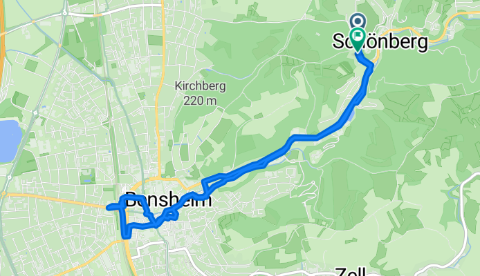
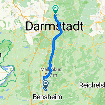
250906 Versorgungstour
A cycling route starting in Bensheim, Hesse, Germany.
Overview
About this route
- 41 min
- Duration
- 7.5 km
- Distance
- 43 m
- Ascent
- 60 m
- Descent
- 11.1 km/h
- Avg. speed
- 174 m
- Max. altitude

Continue with Bikemap
Use, edit, or download this cycling route
You would like to ride 250906 Versorgungstour or customize it for your own trip? Here is what you can do with this Bikemap route:
Free features
- Save this route as favorite or in collections
- Copy & plan your own version of this route
- Sync your route with Garmin or Wahoo
Premium features
Free trial for 3 days, or one-time payment. More about Bikemap Premium.
- Navigate this route on iOS & Android
- Export a GPX / KML file of this route
- Create your custom printout (try it for free)
- Download this route for offline navigation
Discover more Premium features.
Get Bikemap PremiumFrom our community
Other popular routes starting in Bensheim
 250903 Feierabendtour ADFC
- Distance
- 33.6 km
- Ascent
- 50 m
- Descent
- 63 m
- Location
- Bensheim, Hesse, Germany
 250902 Vortour zur Feierabendtour
- Distance
- 43.3 km
- Ascent
- 118 m
- Descent
- 94 m
- Location
- Bensheim, Hesse, Germany
 Feierabendrunde um dem Hemsberg
- Distance
- 9 km
- Ascent
- 213 m
- Descent
- 213 m
- Location
- Bensheim, Hesse, Germany
 Schillerstraße 36A nach Hirschstraße
- Distance
- 29.8 km
- Ascent
- 248 m
- Descent
- 217 m
- Location
- Bensheim, Hesse, Germany
 abbatical-Tour 2026 - Teil 1
- Distance
- 2,796.5 km
- Ascent
- 8,582 m
- Descent
- 8,583 m
- Location
- Bensheim, Hesse, Germany
 Bensheim - Lindenfels - Felsberg - Bensheim
- Distance
- 37.9 km
- Ascent
- 944 m
- Descent
- 941 m
- Location
- Bensheim, Hesse, Germany
 Bensheim - Altrip
- Distance
- 42.8 km
- Ascent
- 110 m
- Descent
- 110 m
- Location
- Bensheim, Hesse, Germany
 abbatical-Tour 2026 - Teil 2
- Distance
- 2,796.5 km
- Ascent
- 8,582 m
- Descent
- 8,583 m
- Location
- Bensheim, Hesse, Germany
Open it in the app