
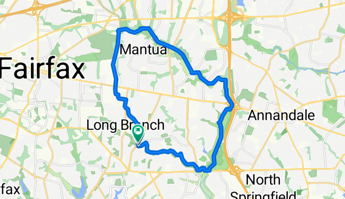
Diddle Loop
A cycling route starting in Kings Park, Virginia, United States.
Overview
About this route
- 1 h 1 min
- Duration
- 19.4 km
- Distance
- 114 m
- Ascent
- 117 m
- Descent
- 18.9 km/h
- Avg. speed
- 131 m
- Max. altitude
Route photos

Route quality
Waytypes & surfaces along the route
Waytypes
Cycleway
12 km
(62 %)
Path
4.6 km
(24 %)
Surfaces
Paved
12.5 km
(64 %)
Unpaved
4.1 km
(21 %)
Asphalt
9.8 km
(51 %)
Gravel
3.9 km
(20 %)
Continue with Bikemap
Use, edit, or download this cycling route
You would like to ride Diddle Loop or customize it for your own trip? Here is what you can do with this Bikemap route:
Free features
- Save this route as favorite or in collections
- Copy & plan your own version of this route
- Sync your route with Garmin or Wahoo
Premium features
Free trial for 3 days, or one-time payment. More about Bikemap Premium.
- Navigate this route on iOS & Android
- Export a GPX / KML file of this route
- Create your custom printout (try it for free)
- Download this route for offline navigation
Discover more Premium features.
Get Bikemap PremiumFrom our community
Other popular routes starting in Kings Park
 home to Lake Accotink
- Distance
- 6.5 km
- Ascent
- 38 m
- Descent
- 68 m
- Location
- Kings Park, Virginia, United States
 Long Route Accontik
- Distance
- 11.4 km
- Ascent
- 105 m
- Descent
- 106 m
- Location
- Kings Park, Virginia, United States
 Steady ride in Burke
- Distance
- 13.7 km
- Ascent
- 132 m
- Descent
- 146 m
- Location
- Kings Park, Virginia, United States
 Diddle Loop
- Distance
- 19.4 km
- Ascent
- 114 m
- Descent
- 117 m
- Location
- Kings Park, Virginia, United States
 First Choice
- Distance
- 10.5 km
- Ascent
- 148 m
- Descent
- 147 m
- Location
- Kings Park, Virginia, United States
 Eastbourne Drive 5500, Springfield to Big Springs Court 42275, Leesburg
- Distance
- 56.6 km
- Ascent
- 614 m
- Descent
- 638 m
- Location
- Kings Park, Virginia, United States
 5603 Mt Burnside Way, Burke to 5603 Mt Burnside Way, Burke
- Distance
- 16.4 km
- Ascent
- 108 m
- Descent
- 114 m
- Location
- Kings Park, Virginia, United States
 5601 Mt Burnside Way, Burke to 5603 Mt Burnside Way, Burke
- Distance
- 16 km
- Ascent
- 135 m
- Descent
- 137 m
- Location
- Kings Park, Virginia, United States
Open it in the app