
moin moin
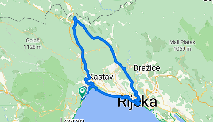
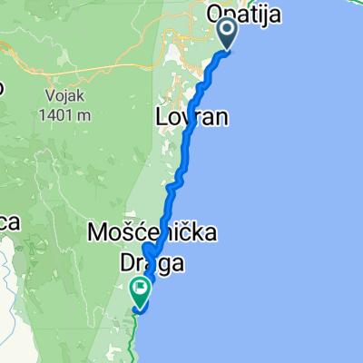
A cycling route starting in Opatija, Primorje-Gorski Kotar County, Croatia.
Overview
About this route
- 3 h 37 min
- Duration
- 66.2 km
- Distance
- 1,197 m
- Ascent
- 1,179 m
- Descent
- 18.3 km/h
- Avg. speed
- 580 m
- Max. altitude

Route quality
Waytypes & surfaces along the route
Waytypes
Quiet road
9.3 km
(14 %)
Road
3.3 km
(5 %)
Surfaces
Paved
56.9 km
(86 %)
Asphalt
56.9 km
(86 %)
Undefined
9.3 km
(14 %)
Continue with Bikemap
Use, edit, or download this cycling route
You would like to ride moin moin or customize it for your own trip? Here is what you can do with this Bikemap route:
Free features
- Save this route as favorite or in collections
- Copy & plan your own version of this route
- Sync your route with Garmin or Wahoo
Premium features
Free trial for 3 days, or one-time payment. More about Bikemap Premium.
- Navigate this route on iOS & Android
- Export a GPX / KML file of this route
- Create your custom printout (try it for free)
- Download this route for offline navigation
Discover more Premium features.
Get Bikemap PremiumFrom our community
Other popular routes starting in Opatija
 Kroatien - Kvarner Bucht- Ucka
- Distance
- 62.2 km
- Ascent
- 1,782 m
- Descent
- 1,777 m
- Location
- Opatija, Primorje-Gorski Kotar County, Croatia
 Stari Grad, Veprinac nach Emila Bošnjaka, Opatija
- Distance
- 5.9 km
- Ascent
- 108 m
- Descent
- 520 m
- Location
- Opatija, Primorje-Gorski Kotar County, Croatia
 Ulica Antona Raspora nach D66
- Distance
- 17.5 km
- Ascent
- 169 m
- Descent
- 233 m
- Location
- Opatija, Primorje-Gorski Kotar County, Croatia
 Opatija-Učka-Lupoglav-Matulji-Opatija
- Distance
- 99.3 km
- Ascent
- 2,294 m
- Descent
- 2,239 m
- Location
- Opatija, Primorje-Gorski Kotar County, Croatia
 08. LK Brdo-LK Lanišće-LK Brdo
- Distance
- 20.1 km
- Ascent
- 450 m
- Descent
- 450 m
- Location
- Opatija, Primorje-Gorski Kotar County, Croatia
 opatija veprinqc
- Distance
- 25.8 km
- Ascent
- 576 m
- Descent
- 576 m
- Location
- Opatija, Primorje-Gorski Kotar County, Croatia
 Učka bike 1
- Distance
- 14.2 km
- Ascent
- 360 m
- Descent
- 359 m
- Location
- Opatija, Primorje-Gorski Kotar County, Croatia
 Snehová cesta vo Opatija
- Distance
- 2.1 km
- Ascent
- 8 m
- Descent
- 76 m
- Location
- Opatija, Primorje-Gorski Kotar County, Croatia
Open it in the app