Vsetín - Dušná kolem hvězdárny
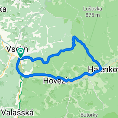
A cycling route starting in Vsetín, Zlín, Czechia.
Overview
About this route
Rychlá Dušná, lesem po asfaltu, za Dušnou makadam lesem, sjezd po asfaltu do Vesníku
- -:--
- Duration
- 16.4 km
- Distance
- 484 m
- Ascent
- 487 m
- Descent
- ---
- Avg. speed
- ---
- Avg. speed
Route quality
Waytypes & surfaces along the route
Waytypes
Track
6.7 km
(41 %)
Road
5.6 km
(34 %)
Surfaces
Paved
10.5 km
(64 %)
Unpaved
1.6 km
(10 %)
Asphalt
10.4 km
(64 %)
Loose gravel
1.6 km
(10 %)
Route highlights
Points of interest along the route
Point of interest after 14.4 km
Continue with Bikemap
Use, edit, or download this cycling route
You would like to ride Vsetín - Dušná kolem hvězdárny or customize it for your own trip? Here is what you can do with this Bikemap route:
Free features
- Save this route as favorite or in collections
- Copy & plan your own version of this route
- Sync your route with Garmin or Wahoo
Premium features
Free trial for 3 days, or one-time payment. More about Bikemap Premium.
- Navigate this route on iOS & Android
- Export a GPX / KML file of this route
- Create your custom printout (try it for free)
- Download this route for offline navigation
Discover more Premium features.
Get Bikemap PremiumFrom our community
Other popular routes starting in Vsetín
- SK - 1. etapa - RACAS
- Distance
- 263 km
- Ascent
- 5,939 m
- Descent
- 5,578 m
- Location
- Vsetín, Zlín, Czechia
- MORAVA-1.den-15.7.13
- Distance
- 12.7 km
- Ascent
- 120 m
- Descent
- 130 m
- Location
- Vsetín, Zlín, Czechia
- Vsetím-Pustevny-Solan-Vsetin
- Distance
- 110.7 km
- Ascent
- 1,112 m
- Descent
- 1,112 m
- Location
- Vsetín, Zlín, Czechia
- 10.Vsetin-Spytihnev
- Distance
- 55.1 km
- Ascent
- 222 m
- Descent
- 387 m
- Location
- Vsetín, Zlín, Czechia
- Vsetín - Velké Karlovice - Čarták - Vsacký Cáb - Bystřička
- Distance
- 64.3 km
- Ascent
- 691 m
- Descent
- 728 m
- Location
- Vsetín, Zlín, Czechia
- Trasa s Danem
- Distance
- 34.3 km
- Ascent
- 955 m
- Descent
- 961 m
- Location
- Vsetín, Zlín, Czechia
- 2010 - Přejezd slovenských hor
- Distance
- 351.3 km
- Ascent
- 2,478 m
- Descent
- 2,359 m
- Location
- Vsetín, Zlín, Czechia
- SK - 1. etapa - RACAS
- Distance
- 256 km
- Ascent
- 5,614 m
- Descent
- 5,325 m
- Location
- Vsetín, Zlín, Czechia
Open it in the app