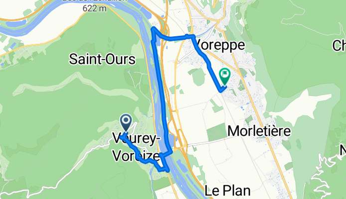
De Allée des Marronniers à Impasse Xavier Bichat
A cycling route starting in Veurey-Voroize, Auvergne-Rhône-Alpes, France.
Overview
About this route
- 27 min
- Duration
- 8.2 km
- Distance
- 36 m
- Ascent
- 198 m
- Descent
- 18.5 km/h
- Avg. speed
- 358 m
- Max. altitude
Route photos
Route quality
Waytypes & surfaces along the route
Waytypes
Cycleway
3 km
(37 %)
Path
2.5 km
(30 %)
Surfaces
Paved
6.3 km
(77 %)
Asphalt
5.8 km
(71 %)
Paved (undefined)
0.5 km
(7 %)
Undefined
1.9 km
(23 %)
Continue with Bikemap
Use, edit, or download this cycling route
You would like to ride De Allée des Marronniers à Impasse Xavier Bichat or customize it for your own trip? Here is what you can do with this Bikemap route:
Free features
- Save this route as favorite or in collections
- Copy & plan your own version of this route
- Sync your route with Garmin or Wahoo
Premium features
Free trial for 3 days, or one-time payment. More about Bikemap Premium.
- Navigate this route on iOS & Android
- Export a GPX / KML file of this route
- Create your custom printout (try it for free)
- Download this route for offline navigation
Discover more Premium features.
Get Bikemap PremiumFrom our community
Other popular routes starting in Veurey-Voroize
- 110114_polienas
- Distance
- 29.5 km
- Ascent
- 42 m
- Descent
- 43 m
- Location
- Veurey-Voroize, Auvergne-Rhône-Alpes, France
- Test tunnel Mortier
- Distance
- 61.3 km
- Ascent
- 1,456 m
- Descent
- 1,345 m
- Location
- Veurey-Voroize, Auvergne-Rhône-Alpes, France
- Etappe 30
- Distance
- 28.8 km
- Ascent
- 76 m
- Descent
- 13 m
- Location
- Veurey-Voroize, Auvergne-Rhône-Alpes, France
- montaud
- Distance
- 6.2 km
- Ascent
- 500 m
- Descent
- 0 m
- Location
- Veurey-Voroize, Auvergne-Rhône-Alpes, France
- Voreppe - Lac d'Aigubelette
- Distance
- 111.8 km
- Ascent
- 1,348 m
- Descent
- 1,351 m
- Location
- Veurey-Voroize, Auvergne-Rhône-Alpes, France
- Moirans Coublevie bis
- Distance
- 32.3 km
- Ascent
- 141 m
- Descent
- 141 m
- Location
- Veurey-Voroize, Auvergne-Rhône-Alpes, France
- tdf 2
- Distance
- 120.1 km
- Ascent
- 2,029 m
- Descent
- 2,031 m
- Location
- Veurey-Voroize, Auvergne-Rhône-Alpes, France
- Saint Jean de Chépy bis
- Distance
- 29.9 km
- Ascent
- 26 m
- Descent
- 27 m
- Location
- Veurey-Voroize, Auvergne-Rhône-Alpes, France
Open it in the app