
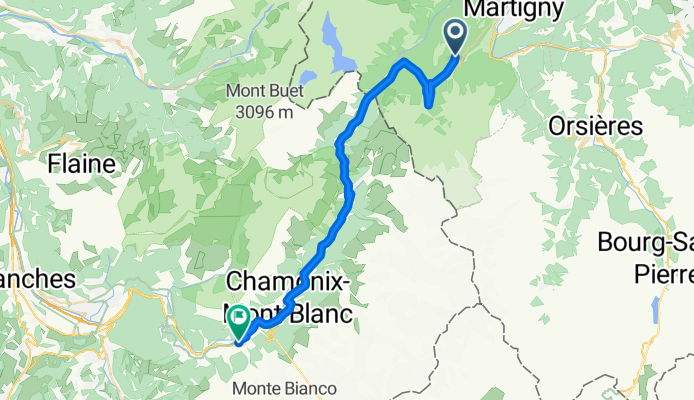
Route de la Forclaz, Martigny-Croix nach Chemin du Glacier de Taconnaz, Chamonix-Mont-Blanc
A cycling route starting in Martigny-Combe, Valais, Switzerland.
Overview
About this route
- 3 h 13 min
- Duration
- 35.6 km
- Distance
- 658 m
- Ascent
- 964 m
- Descent
- 11.1 km/h
- Avg. speed
- 1,528 m
- Max. altitude

Route photos


Route quality
Waytypes & surfaces along the route
Waytypes
Quiet road
5 km
(14 %)
Access road
3.2 km
(9 %)
Surfaces
Paved
27.8 km
(78 %)
Asphalt
27.8 km
(78 %)
Undefined
7.8 km
(22 %)
Continue with Bikemap
Use, edit, or download this cycling route
You would like to ride Route de la Forclaz, Martigny-Croix nach Chemin du Glacier de Taconnaz, Chamonix-Mont-Blanc or customize it for your own trip? Here is what you can do with this Bikemap route:
Free features
- Save this route as favorite or in collections
- Copy & plan your own version of this route
- Sync your route with Garmin or Wahoo
Premium features
Free trial for 3 days, or one-time payment. More about Bikemap Premium.
- Navigate this route on iOS & Android
- Export a GPX / KML file of this route
- Create your custom printout (try it for free)
- Download this route for offline navigation
Discover more Premium features.
Get Bikemap PremiumFrom our community
Other popular routes starting in Martigny-Combe
 Trevor - Champex and Planche
- Distance
- 51.3 km
- Ascent
- 1,740 m
- Descent
- 1,740 m
- Location
- Martigny-Combe, Valais, Switzerland
 Startup Route des Grandes Alpes
- Distance
- 40 km
- Ascent
- 1,360 m
- Descent
- 834 m
- Location
- Martigny-Combe, Valais, Switzerland
 MontBlancTour5Tag
- Distance
- 14 km
- Ascent
- 1,107 m
- Descent
- 935 m
- Location
- Martigny-Combe, Valais, Switzerland
 Trevor Base Route
- Distance
- 93.3 km
- Ascent
- 715 m
- Descent
- 715 m
- Location
- Martigny-Combe, Valais, Switzerland
 Champex and Val Ferret
- Distance
- 62.9 km
- Ascent
- 1,722 m
- Descent
- 1,722 m
- Location
- Martigny-Combe, Valais, Switzerland
 Trevor Flat big loop
- Distance
- 73.5 km
- Ascent
- 303 m
- Descent
- 303 m
- Location
- Martigny-Combe, Valais, Switzerland
 La Chatelard-Lac de Emosson
- Distance
- 18.3 km
- Ascent
- 1,556 m
- Descent
- 838 m
- Location
- Martigny-Combe, Valais, Switzerland
 VTT MONT BLANC Vllorcine Albertville
- Distance
- 432.8 km
- Ascent
- 8,172 m
- Descent
- 8,462 m
- Location
- Martigny-Combe, Valais, Switzerland
Open it in the app