Von München bis Besançon
Koblenz AG - Mülhausen
A cycling route starting in Lauchringen, Baden-Wurttemberg, Germany.
Overview
About this route
- 3 h 50 min
 - Duration
 - 64.5 km
 - Distance
 - 312 m
 - Ascent
 - 521 m
 - Descent
 - 16.8 km/h
 - Avg. speed
 - 477 m
 - Max. altitude
 
Part of
Von München bis Besançon
9 stages
Route quality
Waytypes & surfaces along the route
Waytypes
Quiet road
26.4 km
(41 %)
Path
16.8 km
(26 %)
Surfaces
Paved
52.9 km
(82 %)
Unpaved
5.8 km
(9 %)
Asphalt
51.6 km
(80 %)
Gravel
5.8 km
(9 %)
Continue with Bikemap
Use, edit, or download this cycling route
You would like to ride Koblenz AG - Mülhausen or customize it for your own trip? Here is what you can do with this Bikemap route:
Free features
- Save this route as favorite or in collections
 - Copy & plan your own version of this route
 - Sync your route with Garmin or Wahoo
 
Premium features
Free trial for 3 days, or one-time payment. More about Bikemap Premium.
- Navigate this route on iOS & Android
 - Export a GPX / KML file of this route
 - Create your custom printout (try it for free)
 - Download this route for offline navigation
 
Discover more Premium features.
Get Bikemap PremiumFrom our community
Other popular routes starting in Lauchringen
7. nap Waldshut-Tiengen–Weil am Rhein- Distance
 - 76.8 km
 - Ascent
 - 349 m
 - Descent
 - 429 m
 - Location
 - Lauchringen, Baden-Wurttemberg, Germany
 
Schweiz Rhein Deutschland- Distance
 - 27.2 km
 - Ascent
 - 99 m
 - Descent
 - 99 m
 - Location
 - Lauchringen, Baden-Wurttemberg, Germany
 
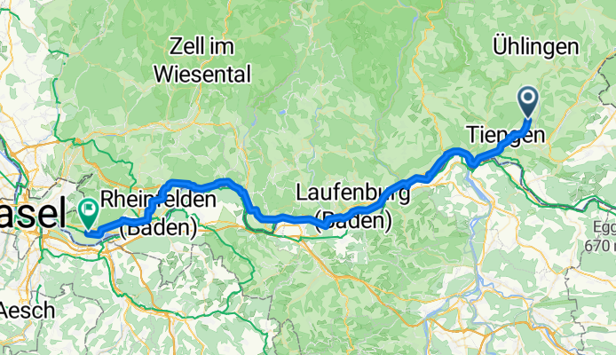
3-TagesTour 3 - Waldshut Küsnacht- Distance
 - 85.7 km
 - Ascent
 - 1,280 m
 - Descent
 - 1,176 m
 - Location
 - Lauchringen, Baden-Wurttemberg, Germany
 
Hochrhein Fluss aufwärts. zurück durch die Schweiz- Distance
 - 25.8 km
 - Ascent
 - 54 m
 - Descent
 - 57 m
 - Location
 - Lauchringen, Baden-Wurttemberg, Germany
 
Koblenz AG - Mülhausen- Distance
 - 64.5 km
 - Ascent
 - 312 m
 - Descent
 - 521 m
 - Location
 - Lauchringen, Baden-Wurttemberg, Germany
 
076b BIKETOUR - Herrmann Waldshut Zürich Final- Distance
 - 69.7 km
 - Ascent
 - 531 m
 - Descent
 - 459 m
 - Location
 - Lauchringen, Baden-Wurttemberg, Germany
 
Die Wutach entlang ins Klettgautal- Distance
 - 46.6 km
 - Ascent
 - 286 m
 - Descent
 - 258 m
 - Location
 - Lauchringen, Baden-Wurttemberg, Germany
 
Entspannte Route- Distance
 - 31.6 km
 - Ascent
 - 113 m
 - Descent
 - 117 m
 - Location
 - Lauchringen, Baden-Wurttemberg, Germany
 
Open it in the app

