

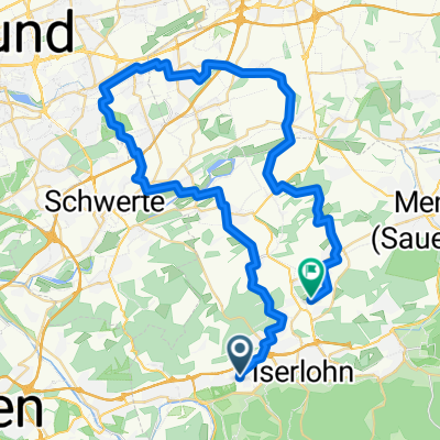
Untergrüne - Hegenscheid - Stadtwald - Jägerpfad
A cycling route starting in Iserlohn, North Rhine-Westphalia, Germany.
Overview
About this route
Untergrüne - Pillingsen - Lössel - Hilkenhöhe - Wixberg - Hegenscheid - Ihmerter Weg (Stadtwald) - Löhen - Dannenhöfer - Jägerpfad - Roden - Saat
Teilweise über Nebenstraßen, teilweise anspruchsvolle Waldwege
- -:--
- Duration
- 26.7 km
- Distance
- 541 m
- Ascent
- 541 m
- Descent
- ---
- Avg. speed
- ---
- Max. altitude

Route quality
Waytypes & surfaces along the route
Waytypes
Track
16 km
(60 %)
Quiet road
9.2 km
(35 %)
Surfaces
Paved
4.6 km
(17 %)
Unpaved
15.1 km
(57 %)
Gravel
9.8 km
(37 %)
Asphalt
4.4 km
(16 %)
Continue with Bikemap
Use, edit, or download this cycling route
You would like to ride Untergrüne - Hegenscheid - Stadtwald - Jägerpfad or customize it for your own trip? Here is what you can do with this Bikemap route:
Free features
- Save this route as favorite or in collections
- Copy & plan your own version of this route
- Sync your route with Garmin or Wahoo
Premium features
Free trial for 3 days, or one-time payment. More about Bikemap Premium.
- Navigate this route on iOS & Android
- Export a GPX / KML file of this route
- Create your custom printout (try it for free)
- Download this route for offline navigation
Discover more Premium features.
Get Bikemap PremiumFrom our community
Other popular routes starting in Iserlohn
 Rund um Letmathe
- Distance
- 14.3 km
- Ascent
- 324 m
- Descent
- 324 m
- Location
- Iserlohn, North Rhine-Westphalia, Germany
 Lössel Evingsen Altena Lössel
- Distance
- 27.8 km
- Ascent
- 687 m
- Descent
- 687 m
- Location
- Iserlohn, North Rhine-Westphalia, Germany
 20201228_132247 BISMARCKTURM
- Distance
- 2.6 km
- Ascent
- 117 m
- Descent
- 109 m
- Location
- Iserlohn, North Rhine-Westphalia, Germany
 Route in Iserlohn
- Distance
- 50 km
- Ascent
- 589 m
- Descent
- 600 m
- Location
- Iserlohn, North Rhine-Westphalia, Germany
 Kalthofer Feld 1, Iserlohn nach Kalthofer Feld 1, Iserlohn
- Distance
- 10 km
- Ascent
- 145 m
- Descent
- 156 m
- Location
- Iserlohn, North Rhine-Westphalia, Germany
 Iserlohner Jedermannstrecke Iserlohn
- Distance
- 20.3 km
- Ascent
- 218 m
- Descent
- 220 m
- Location
- Iserlohn, North Rhine-Westphalia, Germany
 IS-Fröndenberg-Schwerte-IS
- Distance
- 51.1 km
- Ascent
- 271 m
- Descent
- 269 m
- Location
- Iserlohn, North Rhine-Westphalia, Germany
 IS - Deilinghofen - Wocklum - Balve - LA - Garbeck - Neuenrade - IS
- Distance
- 48.5 km
- Ascent
- 992 m
- Descent
- 992 m
- Location
- Iserlohn, North Rhine-Westphalia, Germany
Open it in the app