Steinhuder Meer mit Bergkirchen
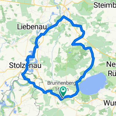
A cycling route starting in Wölpinghausen, Lower Saxony, Germany.
Overview
About this route
Ride clockwise, starting west of Mardorf. Sa/Su only early in the morning, otherwise many groups. In Mardorf do not follow the signs, they only lead to the 'center'. In Mardorf use the waterfront path together with pedestrians. On the east shore, there are short educational trails to the bog. In Steinhude, use the footpath by the sea, possibly descending 500 m. In Hagenburg through the rhododendron park by the castle. especially worthwhile from mid-May to mid-June. Interesting climb from Hagenburg to Bergkirchen, great view of Steinhuder Meer and Schaumburger Land. In Bergkirchen shelter with panoramic view. Dangerous slope before Bad Rehburg, with brakes 45 km/h. Travel time 150 minutes + great pause in Bergkirchen.
- -:--
- Duration
- 41.7 km
- Distance
- 147 m
- Ascent
- 147 m
- Descent
- ---
- Avg. speed
- ---
- Max. altitude
Route quality
Waytypes & surfaces along the route
Waytypes
Track
10.8 km
(26 %)
Pedestrian area
8.3 km
(20 %)
Surfaces
Paved
23.8 km
(57 %)
Unpaved
13.3 km
(32 %)
Asphalt
22.1 km
(53 %)
Gravel
10 km
(24 %)
Continue with Bikemap
Use, edit, or download this cycling route
You would like to ride Steinhuder Meer mit Bergkirchen or customize it for your own trip? Here is what you can do with this Bikemap route:
Free features
- Save this route as favorite or in collections
- Copy & plan your own version of this route
- Sync your route with Garmin or Wahoo
Premium features
Free trial for 3 days, or one-time payment. More about Bikemap Premium.
- Navigate this route on iOS & Android
- Export a GPX / KML file of this route
- Create your custom printout (try it for free)
- Download this route for offline navigation
Discover more Premium features.
Get Bikemap PremiumFrom our community
Other popular routes starting in Wölpinghausen
- Hagenburg
- Distance
- 13.3 km
- Ascent
- 257 m
- Descent
- 250 m
- Location
- Wölpinghausen, Lower Saxony, Germany
- Bahnhofstraße, Rehburg-Loccum nach Bahnhofstraße, Rehburg-Loccum
- Distance
- 46.4 km
- Ascent
- 102 m
- Descent
- 104 m
- Location
- Wölpinghausen, Lower Saxony, Germany
- Route nach Südstraße, 31547 Rehburg-Loccum
- Distance
- 31 km
- Ascent
- 58 m
- Descent
- 57 m
- Location
- Wölpinghausen, Lower Saxony, Germany
- Bahnhofstraße, Rehburg-Loccum nach Bahnhofstraße, Rehburg-Loccum
- Distance
- 42.6 km
- Ascent
- 403 m
- Descent
- 407 m
- Location
- Wölpinghausen, Lower Saxony, Germany
- Schierstraße, Rehburg-Loccum nach Bahnhofstraße, Rehburg-Loccum
- Distance
- 178.2 km
- Ascent
- 342 m
- Descent
- 347 m
- Location
- Wölpinghausen, Lower Saxony, Germany
- Meerrunde
- Distance
- 46.7 km
- Ascent
- 185 m
- Descent
- 185 m
- Location
- Wölpinghausen, Lower Saxony, Germany
- Bahnhofstraße, Rehburg-Loccum nach Bahnhofstraße, Rehburg-Loccum
- Distance
- 42.7 km
- Ascent
- 403 m
- Descent
- 413 m
- Location
- Wölpinghausen, Lower Saxony, Germany
- Bad Rehburg-Ilse
- Distance
- 36.8 km
- Ascent
- 196 m
- Descent
- 195 m
- Location
- Wölpinghausen, Lower Saxony, Germany
Open it in the app