

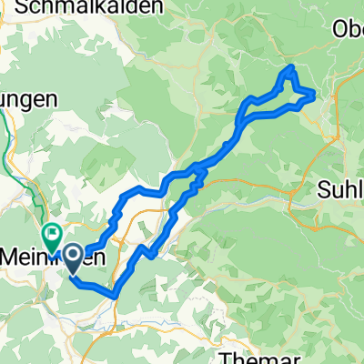
Noch 'ne 'kleine' Abendrunde - Stage 2
A cycling route starting in Meiningen, Thuringia, Germany.
Overview
About this route
Mit ein wenig Downhill den Berg/Hügel herunter, den Werra-Radweg bis Walldorf, dann bis Wallbach und seiner Mühle.
Weiter nach Metzels (ein wenig den Berg hinauf) und dann um den Dolmar herum nach Kühndorf. Zwischendurch trifft man auf die Straße zum Charlottenhaus, wer etwas mehr Training wünscht, darf hier rechts statt links abbiegen und den Gipfel erklimmen.
Kühndorf bis Meiningen ist gut geeignet, den Schnitt zu verbessern. Zu guter letzt wieder die Frankfurter Straße hinauf...
- -:--
- Duration
- 45.2 km
- Distance
- 632 m
- Ascent
- 697 m
- Descent
- ---
- Avg. speed
- 596 m
- Max. altitude
Route quality
Waytypes & surfaces along the route
Waytypes
Track
28.9 km
(64 %)
Quiet road
4.5 km
(10 %)
Surfaces
Paved
15.4 km
(34 %)
Unpaved
22.6 km
(50 %)
Gravel
16.3 km
(36 %)
Asphalt
13.1 km
(29 %)
Continue with Bikemap
Use, edit, or download this cycling route
You would like to ride Noch 'ne 'kleine' Abendrunde - Stage 2 or customize it for your own trip? Here is what you can do with this Bikemap route:
Free features
- Save this route as favorite or in collections
- Copy & plan your own version of this route
- Sync your route with Garmin or Wahoo
Premium features
Free trial for 3 days, or one-time payment. More about Bikemap Premium.
- Navigate this route on iOS & Android
- Export a GPX / KML file of this route
- Create your custom printout (try it for free)
- Download this route for offline navigation
Discover more Premium features.
Get Bikemap PremiumFrom our community
Other popular routes starting in Meiningen
 Rundfahrt mit Eike
- Distance
- 35.1 km
- Ascent
- 374 m
- Descent
- 388 m
- Location
- Meiningen, Thuringia, Germany
 Von Meiningen bis Steinbach
- Distance
- 38.4 km
- Ascent
- 337 m
- Descent
- 229 m
- Location
- Meiningen, Thuringia, Germany
 Meiningen nach Ernestinerstraße, Meiningen
- Distance
- 60 km
- Ascent
- 1,084 m
- Descent
- 1,278 m
- Location
- Meiningen, Thuringia, Germany
 Am Wandervogel 37, Meiningen nach Am Wandervogel 37, Meiningen
- Distance
- 31.4 km
- Ascent
- 491 m
- Descent
- 491 m
- Location
- Meiningen, Thuringia, Germany
 Meiningen-Kühndorf-Metzels-Oberwallbachmühle-MGN
- Distance
- 30.3 km
- Ascent
- 409 m
- Descent
- 432 m
- Location
- Meiningen, Thuringia, Germany
 Ernestinerstraße, Meiningen nach Ernestinerstraße, Meiningen
- Distance
- 57.6 km
- Ascent
- 1,362 m
- Descent
- 1,362 m
- Location
- Meiningen, Thuringia, Germany
 Noch 'ne 'kleine' Abendrunde - Stage 2
- Distance
- 45.2 km
- Ascent
- 632 m
- Descent
- 697 m
- Location
- Meiningen, Thuringia, Germany
 1.Tag:Meiningen-Hilders/Eckweisbach
- Distance
- 55.7 km
- Ascent
- 969 m
- Descent
- 823 m
- Location
- Meiningen, Thuringia, Germany
Open it in the app