
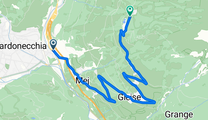
ASCENSO A JAFFERAU (por Bardonecchia)
A cycling route starting in Bardonecchia, Piedmont, Italy.
Overview
About this route
The climb to Jafferau (1932 m) is one of Piedmont's most legendary ascents and a pass closely tied to the history of the Giro d'Italia. Situated above the town of Bardonecchia, at the western end of the Italian Alps, it combines alpine beauty with considerable severity. It's not a long climb, but it is extremely demanding, with constant ramps that rarely drop below 9%, giving it an explosive and selective character. Its road is narrow, carved into the mountain landscape, and reinforces the sense of isolation that makes this pass an epic setting for cycling.
- 38 min
- Duration
- 7.9 km
- Distance
- 695 m
- Ascent
- 25 m
- Descent
- 12.3 km/h
- Avg. speed
- 1,939 m
- Max. altitude

Route photos
\"")
Route quality
Waytypes & surfaces along the route
Waytypes
Quiet road
7.9 km
(100 %)
Surfaces
Paved
7.7 km
(98 %)
Unpaved
0.2 km
(2 %)
Asphalt
7.7 km
(98 %)
Loose gravel
0.2 km
(2 %)
Continue with Bikemap
Use, edit, or download this cycling route
You would like to ride ASCENSO A JAFFERAU (por Bardonecchia) or customize it for your own trip? Here is what you can do with this Bikemap route:
Free features
- Save this route as favorite or in collections
- Copy & plan your own version of this route
- Sync your route with Garmin or Wahoo
Premium features
Free trial for 3 days, or one-time payment. More about Bikemap Premium.
- Navigate this route on iOS & Android
- Export a GPX / KML file of this route
- Create your custom printout (try it for free)
- Download this route for offline navigation
Discover more Premium features.
Get Bikemap PremiumFrom our community
Other popular routes starting in Bardonecchia
 Fort Jafferau view Col Basset (Retour bij FJ!)
- Distance
- 41.4 km
- Ascent
- 1,717 m
- Descent
- 1,717 m
- Location
- Bardonecchia, Piedmont, Italy
 2018/13 bardonecchia to Milan
- Distance
- 305.8 km
- Ascent
- 247 m
- Descent
- 1,377 m
- Location
- Bardonecchia, Piedmont, Italy
 Colle Rho
- Distance
- 12.6 km
- Ascent
- 1,279 m
- Descent
- 0 m
- Location
- Bardonecchia, Piedmont, Italy
 Colle della Rho, Refuge du Mont-Thabor, and Col de la Vallée Etroite
- Distance
- 41.1 km
- Ascent
- 1,795 m
- Descent
- 1,797 m
- Location
- Bardonecchia, Piedmont, Italy
 italy
italy- Distance
- 717.6 km
- Ascent
- 60 m
- Descent
- 1,543 m
- Location
- Bardonecchia, Piedmont, Italy
 1. WestalpenX2011_Bardonecchia (Melezet) - Montgenèvre
- Distance
- 29.5 km
- Ascent
- 0 m
- Descent
- 0 m
- Location
- Bardonecchia, Piedmont, Italy
 Coll de Somellier
- Distance
- 24.7 km
- Ascent
- 1,837 m
- Descent
- 148 m
- Location
- Bardonecchia, Piedmont, Italy
 Fort Jafferau view Col Basset
- Distance
- 41.5 km
- Ascent
- 1,717 m
- Descent
- 1,717 m
- Location
- Bardonecchia, Piedmont, Italy
Open it in the app