

Laziner Alm
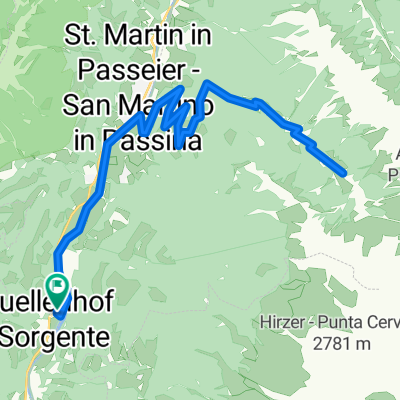
A cycling route starting in San Martino in Passiria, Trentino-Alto Adige, Italy.
Overview
About this route
Teilweise lange, gerade bergauf Abschnitte die sehr ermüdend sind.
Trotzdem für meine Begriffe wunderschöne Tour mit atemberaubender Aussicht aufs Timmelsjoch sowie die Hohe Weiße und Hohe Wilde. Das Pfelderer Tal ist gleichfalls wunderschön. Zur Belohnung gab es auf der Alm ein Weizenbier.- -:--
- Duration
- 55.6 km
- Distance
- 1,360 m
- Ascent
- 1,360 m
- Descent
- ---
- Avg. speed
- ---
- Max. altitude

Route quality
Waytypes & surfaces along the route
Waytypes
Track
24.3 km
(44 %)
Road
17.9 km
(32 %)
Surfaces
Paved
24.5 km
(44 %)
Unpaved
24 km
(43 %)
Asphalt
23.8 km
(43 %)
Loose gravel
11.2 km
(20 %)
Continue with Bikemap
Use, edit, or download this cycling route
You would like to ride Laziner Alm or customize it for your own trip? Here is what you can do with this Bikemap route:
Free features
- Save this route as favorite or in collections
- Copy & plan your own version of this route
- Sync your route with Garmin or Wahoo
Premium features
Free trial for 3 days, or one-time payment. More about Bikemap Premium.
- Navigate this route on iOS & Android
- Export a GPX / KML file of this route
- Create your custom printout (try it for free)
- Download this route for offline navigation
Discover more Premium features.
Get Bikemap PremiumFrom our community
Other popular routes starting in San Martino in Passiria
 Hirzer Runde
- Distance
- 29.6 km
- Ascent
- 1,572 m
- Descent
- 1,569 m
- Location
- San Martino in Passiria, Trentino-Alto Adige, Italy
 Meran
Meran- Distance
- 26.5 km
- Ascent
- 604 m
- Descent
- 603 m
- Location
- San Martino in Passiria, Trentino-Alto Adige, Italy
 Tour zumTimmelsjoch
- Distance
- 38.1 km
- Ascent
- 2,169 m
- Descent
- 209 m
- Location
- San Martino in Passiria, Trentino-Alto Adige, Italy
 Pfandleralm
- Distance
- 23.6 km
- Ascent
- 820 m
- Descent
- 830 m
- Location
- San Martino in Passiria, Trentino-Alto Adige, Italy
 Fartleiser Alm
- Distance
- 27 km
- Ascent
- 975 m
- Descent
- 975 m
- Location
- San Martino in Passiria, Trentino-Alto Adige, Italy
 Steinhauser Waalweg
- Distance
- 17.3 km
- Ascent
- 509 m
- Descent
- 508 m
- Location
- San Martino in Passiria, Trentino-Alto Adige, Italy
 Meran
Meran- Distance
- 24.4 km
- Ascent
- 264 m
- Descent
- 265 m
- Location
- San Martino in Passiria, Trentino-Alto Adige, Italy
 Hinterbrugg Trail ab Breiteben, Start Quellenhof
- Distance
- 25.3 km
- Ascent
- 540 m
- Descent
- 534 m
- Location
- San Martino in Passiria, Trentino-Alto Adige, Italy
Open it in the app