Szentendre-Bank
A cycling route starting in Szentendre, Pest County, Hungary.
Overview
About this route
- 3 h 13 min
- Duration
- 51.7 km
- Distance
- 597 m
- Ascent
- 503 m
- Descent
- 16.1 km/h
- Avg. speed
- 297 m
- Max. altitude
Route quality
Waytypes & surfaces along the route
Waytypes
Quiet road
5.7 km
(11 %)
Cycleway
5.7 km
(11 %)
Surfaces
Paved
45.5 km
(88 %)
Asphalt
45.5 km
(88 %)
Undefined
6.2 km
(12 %)
Continue with Bikemap
Use, edit, or download this cycling route
You would like to ride Szentendre-Bank or customize it for your own trip? Here is what you can do with this Bikemap route:
Free features
- Save this route as favorite or in collections
- Copy & plan your own version of this route
- Sync your route with Garmin or Wahoo
Premium features
Free trial for 3 days, or one-time payment. More about Bikemap Premium.
- Navigate this route on iOS & Android
- Export a GPX / KML file of this route
- Create your custom printout (try it for free)
- Download this route for offline navigation
Discover more Premium features.
Get Bikemap PremiumFrom our community
Other popular routes starting in Szentendre
Postás strand- Omszki tó- Distance
- 15 km
- Ascent
- 17 m
- Descent
- 16 m
- Location
- Szentendre, Pest County, Hungary
Dobogókő !- Distance
- 45 km
- Ascent
- 802 m
- Descent
- 802 m
- Location
- Szentendre, Pest County, Hungary
Útvonal ide: Állomás tér hrsz- Distance
- 58.3 km
- Ascent
- 1,231 m
- Descent
- 1,274 m
- Location
- Szentendre, Pest County, Hungary
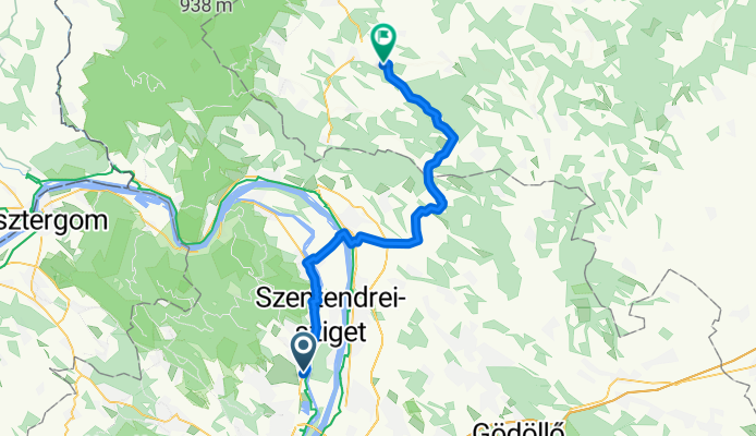
Strand utca to Arany János utca- Distance
- 23.6 km
- Ascent
- 60 m
- Descent
- 99 m
- Location
- Szentendre, Pest County, Hungary
D15 Szentendre - Budapest- Distance
- 26.7 km
- Ascent
- 124 m
- Descent
- 109 m
- Location
- Szentendre, Pest County, Hungary
Ady Endre utca, Szentendre - Váci Mihály utca, Sződ- Distance
- 35 km
- Ascent
- 118 m
- Descent
- 107 m
- Location
- Szentendre, Pest County, Hungary
Szentendre-Bank- Distance
- 51.7 km
- Ascent
- 597 m
- Descent
- 503 m
- Location
- Szentendre, Pest County, Hungary
Ady Endre utca, Szentendre - Ady Endre utca, Szentendre- Distance
- 54.3 km
- Ascent
- 528 m
- Descent
- 527 m
- Location
- Szentendre, Pest County, Hungary
Open it in the app


