
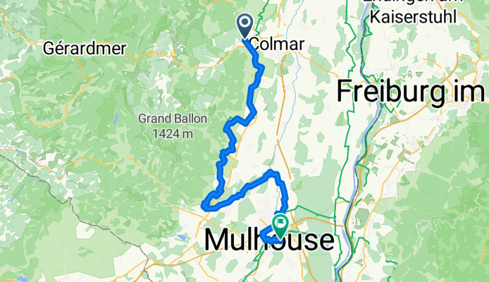
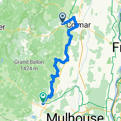
Von Türkheim bis Riedisheim
A cycling route starting in Turckheim, Grand Est, France.
Overview
About this route
- 5 h 3 min
- Duration
- 89.3 km
- Distance
- 392 m
- Ascent
- 385 m
- Descent
- 17.7 km/h
- Avg. speed
- 302 m
- Max. altitude
Route quality
Waytypes & surfaces along the route
Waytypes
Quiet road
32.1 km
(36 %)
Cycleway
27.7 km
(31 %)
Surfaces
Paved
61.6 km
(69 %)
Asphalt
50 km
(56 %)
Paved (undefined)
8.9 km
(10 %)
Continue with Bikemap
Use, edit, or download this cycling route
You would like to ride Von Türkheim bis Riedisheim or customize it for your own trip? Here is what you can do with this Bikemap route:
Free features
- Save this route as favorite or in collections
- Copy & plan your own version of this route
- Split it into stages to create a multi-day tour
- Sync your route with Garmin or Wahoo
Premium features
Free trial for 3 days, or one-time payment. More about Bikemap Premium.
- Navigate this route on iOS & Android
- Export a GPX / KML file of this route
- Create your custom printout (try it for free)
- Download this route for offline navigation
Discover more Premium features.
Get Bikemap PremiumFrom our community
Other popular routes starting in Turckheim
 Col de la Schlucht
- Distance
- 29 km
- Ascent
- 911 m
- Descent
- 25 m
- Location
- Turckheim, Grand Est, France
 Col de la Schlucht über Münstertal
- Distance
- 73.4 km
- Ascent
- 1,338 m
- Descent
- 1,338 m
- Location
- Turckheim, Grand Est, France
 From Turckheim to Oberhausbergen
- Distance
- 85.9 km
- Ascent
- 69 m
- Descent
- 165 m
- Location
- Turckheim, Grand Est, France
 Mäusis Vogesen-Debüt :-)
- Distance
- 41.8 km
- Ascent
- 798 m
- Descent
- 801 m
- Location
- Turckheim, Grand Est, France
 J3 Turckheim to Cernay
- Distance
- 63.6 km
- Ascent
- 356 m
- Descent
- 295 m
- Location
- Turckheim, Grand Est, France
 3chtx-first-3épis
- Distance
- 55 km
- Ascent
- 1,308 m
- Descent
- 1,302 m
- Location
- Turckheim, Grand Est, France
 Niedermorschwihr-Orbey
- Distance
- 33.5 km
- Ascent
- 628 m
- Descent
- 628 m
- Location
- Turckheim, Grand Est, France
 Alsace Etappe 2
- Distance
- 73.9 km
- Ascent
- 274 m
- Descent
- 332 m
- Location
- Turckheim, Grand Est, France
Open it in the app