Wood Ave, Armstrong to 32nd Ave, Vernon
A cycling route starting in Armstrong, British Columbia, Canada.
Overview
About this route
- 1 h 23 min
- Duration
- 28.8 km
- Distance
- 433 m
- Ascent
- 409 m
- Descent
- 20.7 km/h
- Avg. speed
- 541 m
- Max. altitude
Route quality
Waytypes & surfaces along the route
Waytypes
Road
12.1 km
(42 %)
Quiet road
9.8 km
(34 %)
Undefined
6.9 km
(24 %)
Surfaces
Paved
24.8 km
(86 %)
Unpaved
4.3 km
(15 %)
Paved (undefined)
24.5 km
(85 %)
Unpaved (undefined)
4.3 km
(15 %)
Continue with Bikemap
Use, edit, or download this cycling route
You would like to ride Wood Ave, Armstrong to 32nd Ave, Vernon or customize it for your own trip? Here is what you can do with this Bikemap route:
Free features
- Save this route as favorite or in collections
- Copy & plan your own version of this route
- Sync your route with Garmin or Wahoo
Premium features
Free trial for 3 days, or one-time payment. More about Bikemap Premium.
- Navigate this route on iOS & Android
- Export a GPX / KML file of this route
- Create your custom printout (try it for free)
- Download this route for offline navigation
Discover more Premium features.
Get Bikemap PremiumFrom our community
Other popular routes starting in Armstrong
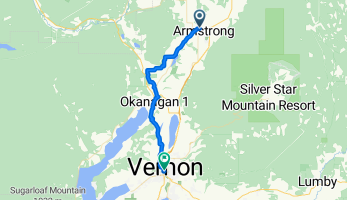
Armstrong Fondo Club- Distance
- 115 km
- Ascent
- 498 m
- Descent
- 500 m
- Location
- Armstrong, British Columbia, Canada
McLeod subdivision- Distance
- 39 km
- Ascent
- 416 m
- Descent
- 426 m
- Location
- Armstrong, British Columbia, Canada

3122®
Armstrong Cycling- Distance
- 19 km
- Ascent
- 381 m
- Descent
- 707 m
- Location
- Armstrong, British Columbia, Canada
Route from 4522–4530 Hullcar Rd, Armstrong- Distance
- 11.2 km
- Ascent
- 109 m
- Descent
- 116 m
- Location
- Armstrong, British Columbia, Canada
3525 Mill St, Armstrong to 710–720 Cliff Ave, Enderby- Distance
- 18.1 km
- Ascent
- 91 m
- Descent
- 94 m
- Location
- Armstrong, British Columbia, Canada
3700 Highland Park Rd, Armstrong to 2505 Pleasant Valley Blvd, Armstrong- Distance
- 34 km
- Ascent
- 320 m
- Descent
- 317 m
- Location
- Armstrong, British Columbia, Canada
Armstrong Century Ride 2014- Distance
- 100.7 km
- Ascent
- 655 m
- Descent
- 654 m
- Location
- Armstrong, British Columbia, Canada
973 Otter Lake cross Rd, Spallumcheen to 3265 Pleasant Valley Rd, Armstrong- Distance
- 64.6 km
- Ascent
- 965 m
- Descent
- 1,011 m
- Location
- Armstrong, British Columbia, Canada
Open it in the app

