
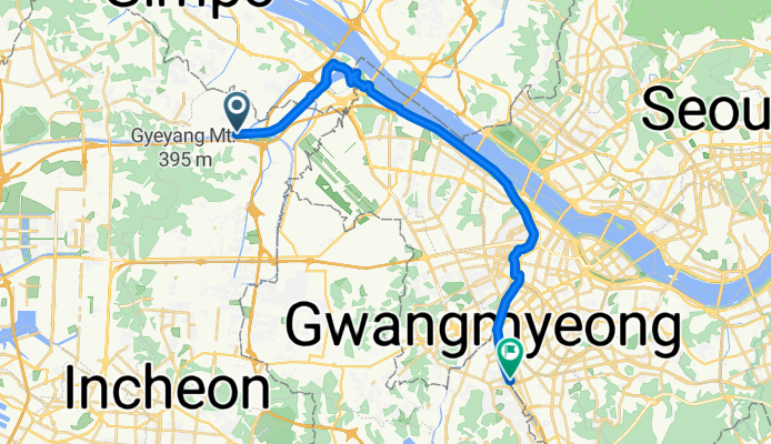
장기동, 인천광역시에서 가산동, 서울특별시까지
A cycling route starting in Bucheon-si, Gyeonggi-do, South Korea.
Overview
About this route
- 1 h 44 min
- Duration
- 28.1 km
- Distance
- 126 m
- Ascent
- 119 m
- Descent
- 16.3 km/h
- Avg. speed
- 19 m
- Max. altitude

Continue with Bikemap
Use, edit, or download this cycling route
You would like to ride 장기동, 인천광역시에서 가산동, 서울특별시까지 or customize it for your own trip? Here is what you can do with this Bikemap route:
Free features
- Save this route as favorite or in collections
- Copy & plan your own version of this route
- Sync your route with Garmin or Wahoo
Premium features
Free trial for 3 days, or one-time payment. More about Bikemap Premium.
- Navigate this route on iOS & Android
- Export a GPX / KML file of this route
- Create your custom printout (try it for free)
- Download this route for offline navigation
Discover more Premium features.
Get Bikemap PremiumFrom our community
Other popular routes starting in Bucheon-si
 원당동, 인천광역시에서 장기동, 인천광역시까지
- Distance
- 7.3 km
- Ascent
- 61 m
- Descent
- 69 m
- Location
- Bucheon-si, Gyeonggi-do, South Korea
 251003 아라뱃길 55km
- Distance
- 53.5 km
- Ascent
- 209 m
- Descent
- 224 m
- Location
- Bucheon-si, Gyeonggi-do, South Korea
 Route to 시흥-풍산동 554−4, 고양시
- Distance
- 42.5 km
- Ascent
- 247 m
- Descent
- 264 m
- Location
- Bucheon-si, Gyeonggi-do, South Korea
 쉬운 승차감
- Distance
- 1.9 km
- Ascent
- 61 m
- Descent
- 116 m
- Location
- Bucheon-si, Gyeonggi-do, South Korea
 장기동, 인천광역시에서 가산동, 서울특별시까지
- Distance
- 28.1 km
- Ascent
- 126 m
- Descent
- 119 m
- Location
- Bucheon-si, Gyeonggi-do, South Korea
 250921 한강 30km
- Distance
- 27.9 km
- Ascent
- 463 m
- Descent
- 452 m
- Location
- Bucheon-si, Gyeonggi-do, South Korea
 내발산동 761-1 ~ 외발산동 216-23
- Distance
- 29.2 km
- Ascent
- 28 m
- Descent
- 45 m
- Location
- Bucheon-si, Gyeonggi-do, South Korea
 72 ~ 내발산동 756
- Distance
- 43.5 km
- Ascent
- 45 m
- Descent
- 58 m
- Location
- Bucheon-si, Gyeonggi-do, South Korea
Open it in the app