

Surveyors Ridge MTB Ride
A cycling route starting in Odell, Oregon, United States.
Overview
About this route
3
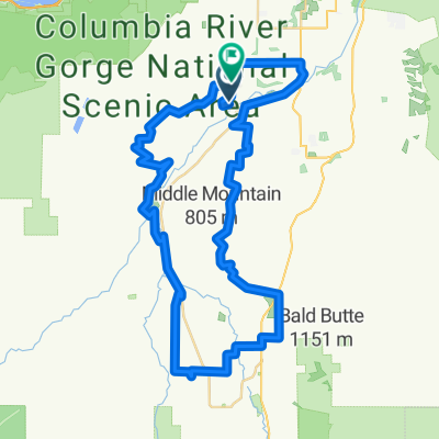
Classic PNW MTB ride!
- -:--
- Duration
- 37.9 km
- Distance
- 929 m
- Ascent
- 929 m
- Descent
- ---
- Avg. speed
- ---
- Max. altitude
danimal
created this 13 years ago
Continue with Bikemap
Use, edit, or download this cycling route
You would like to ride Surveyors Ridge MTB Ride or customize it for your own trip? Here is what you can do with this Bikemap route:
Free features
- Save this route as favorite or in collections
- Copy & plan your own version of this route
- Sync your route with Garmin or Wahoo
Premium features
Free trial for 3 days, or one-time payment. More about Bikemap Premium.
- Navigate this route on iOS & Android
- Export a GPX / KML file of this route
- Create your custom printout (try it for free)
- Download this route for offline navigation
Discover more Premium features.
Get Bikemap PremiumFrom our community
Other popular routes starting in Odell
- 4904–5038 Bassler Dr, Mount Hood Parkdale to 6415–6425 Miller Rd, Mount Hood Parkdale0
- 4.2 km
- 42 m
- 65 m
- Odell, Oregon, United States
- 6740 Trout Creek Ridge Rd, Mount Hood Parkdale to 6740 Trout Creek Ridge Rd, Mount Hood Parkdale0
- 0.1 km
- 0 m
- 0 m
- Odell, Oregon, United States


Open it in the app