
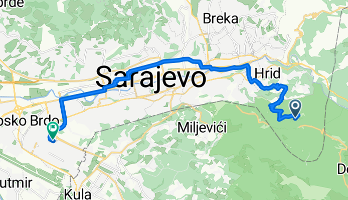
Stari Grad Sarajevo, Sarajevo to Sulejmana Filipovića, Sarajevo
A cycling route starting in Kobilja Glava, Federation of Bosnia and Herzegovina, Bosnia and Herzegovina.
Overview
About this route
- 52 min
- Duration
- 14.8 km
- Distance
- 105 m
- Ascent
- 738 m
- Descent
- 17.2 km/h
- Avg. speed
- 1,148 m
- Max. altitude
Route quality
Waytypes & surfaces along the route
Waytypes
Quiet road
8.1 km
(55 %)
Road
2.5 km
(17 %)
Surfaces
Paved
12.5 km
(85 %)
Unpaved
0.1 km
(1 %)
Asphalt
12.5 km
(85 %)
Ground
0.1 km
(1 %)
Undefined
2.1 km
(14 %)
Continue with Bikemap
Use, edit, or download this cycling route
You would like to ride Stari Grad Sarajevo, Sarajevo to Sulejmana Filipovića, Sarajevo or customize it for your own trip? Here is what you can do with this Bikemap route:
Free features
- Save this route as favorite or in collections
- Copy & plan your own version of this route
- Sync your route with Garmin or Wahoo
Premium features
Free trial for 3 days, or one-time payment. More about Bikemap Premium.
- Navigate this route on iOS & Android
- Export a GPX / KML file of this route
- Create your custom printout (try it for free)
- Download this route for offline navigation
Discover more Premium features.
Get Bikemap PremiumFrom our community
Other popular routes starting in Kobilja Glava
 Сарајево - Θεσσαλονίκη
- Distance
- 914.1 km
- Ascent
- 6,076 m
- Descent
- 6,593 m
- Location
- Kobilja Glava, Federation of Bosnia and Herzegovina, Bosnia and Herzegovina
 CRITERIUM PAUL LOWE 2025
- Distance
- 0.9 km
- Ascent
- 0 m
- Descent
- 0 m
- Location
- Kobilja Glava, Federation of Bosnia and Herzegovina, Bosnia and Herzegovina
 Nevjestina, Sarajevo to Dariva, Sarajevo
- Distance
- 24.9 km
- Ascent
- 439 m
- Descent
- 452 m
- Location
- Kobilja Glava, Federation of Bosnia and Herzegovina, Bosnia and Herzegovina
 Breka - Ilidza - Igman - Hadzici - Blazuj - Ilidza - Breka
- Distance
- 78.8 km
- Ascent
- 2,020 m
- Descent
- 2,011 m
- Location
- Kobilja Glava, Federation of Bosnia and Herzegovina, Bosnia and Herzegovina
 Trebevic Jahorina
- Distance
- 48.4 km
- Ascent
- 1,353 m
- Descent
- 1,353 m
- Location
- Kobilja Glava, Federation of Bosnia and Herzegovina, Bosnia and Herzegovina
 Asphalt_01: Dariva - Vrelo Bosne
- Distance
- 25 km
- Ascent
- 286 m
- Descent
- 317 m
- Location
- Kobilja Glava, Federation of Bosnia and Herzegovina, Bosnia and Herzegovina
 Ruta Smrti
- Distance
- 26.4 km
- Ascent
- 960 m
- Descent
- 1,062 m
- Location
- Kobilja Glava, Federation of Bosnia and Herzegovina, Bosnia and Herzegovina
 Bistrik-Vogošća-Blažuj-Hrasnica-Bistrik
- Distance
- 54.3 km
- Ascent
- 471 m
- Descent
- 470 m
- Location
- Kobilja Glava, Federation of Bosnia and Herzegovina, Bosnia and Herzegovina
Open it in the app