
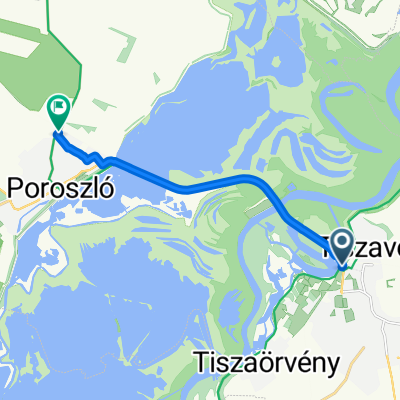
Cil🇭🇺 Csepel A🇭🇺Cic Yxb3 🇭🇺
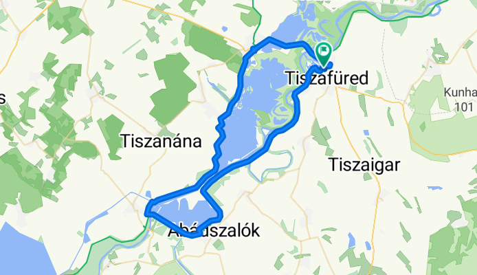
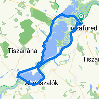
A cycling route starting in Tiszafüred, Jász-Nagykun-Szolnok, Hungary.
Overview
About this route
- 6 h 36 min
- Duration
- 69 km
- Distance
- 146 m
- Ascent
- 212 m
- Descent
- 10.5 km/h
- Avg. speed
- 171 m
- Max. altitude

Route quality
Waytypes & surfaces along the route
Waytypes
Access road
55.2 km
(80 %)
Cycleway
6.2 km
(9 %)
Surfaces
Paved
65.6 km
(95 %)
Asphalt
64.9 km
(94 %)
Concrete
0.7 km
(1 %)
Undefined
3.5 km
(5 %)
Continue with Bikemap
Use, edit, or download this cycling route
You would like to ride Cil🇭🇺 Csepel A🇭🇺Cic Yxb3 🇭🇺 or customize it for your own trip? Here is what you can do with this Bikemap route:
Free features
- Save this route as favorite or in collections
- Copy & plan your own version of this route
- Sync your route with Garmin or Wahoo
Premium features
Free trial for 3 days, or one-time payment. More about Bikemap Premium.
- Navigate this route on iOS & Android
- Export a GPX / KML file of this route
- Create your custom printout (try it for free)
- Download this route for offline navigation
Discover more Premium features.
Get Bikemap PremiumFrom our community
Other popular routes starting in Tiszafüred
 Tisza-tó kör
- Distance
- 67 km
- Ascent
- 81 m
- Descent
- 78 m
- Location
- Tiszafüred, Jász-Nagykun-Szolnok, Hungary
 Füredi út, Tiszafüred to Tiszafüred
- Distance
- 1.6 km
- Ascent
- 48 m
- Descent
- 38 m
- Location
- Tiszafüred, Jász-Nagykun-Szolnok, Hungary
 Húszöles út, Tiszafüred - Húszöles út, Tiszafüred
- Distance
- 65.4 km
- Ascent
- 62 m
- Descent
- 57 m
- Location
- Tiszafüred, Jász-Nagykun-Szolnok, Hungary
 Húszöles út - Húszöles út
- Distance
- 66.5 km
- Ascent
- 66 m
- Descent
- 67 m
- Location
- Tiszafüred, Jász-Nagykun-Szolnok, Hungary
 Útvonal innen: Tiszahíd 33-as
- Distance
- 65 km
- Ascent
- 101 m
- Descent
- 144 m
- Location
- Tiszafüred, Jász-Nagykun-Szolnok, Hungary
 Aradi út - Poroszló
- Distance
- 9 km
- Ascent
- 18 m
- Descent
- 20 m
- Location
- Tiszafüred, Jász-Nagykun-Szolnok, Hungary
 Tiszató kör.
- Distance
- 74.1 km
- Ascent
- 235 m
- Descent
- 276 m
- Location
- Tiszafüred, Jász-Nagykun-Szolnok, Hungary
 Húszöles út, Tiszafüred - Húszöles út, Tiszafüred
- Distance
- 64.3 km
- Ascent
- 53 m
- Descent
- 53 m
- Location
- Tiszafüred, Jász-Nagykun-Szolnok, Hungary
Open it in the app