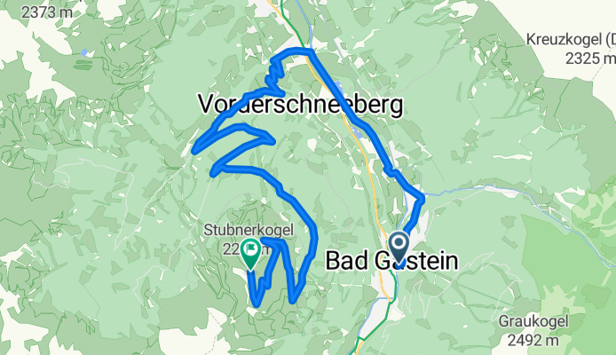
Stubnerkogel von Bad Gastein
A cycling route starting in Bad Gastein, Salzburg, Austria.
Overview
About this route
'Summit‑conqueror tour with over 1400 metres of elevation to the panoramic mountain Stubnerkogel. This tour is recommended for riders who are well trained in fitness. The starting point is the bike start area in the town centre of Bad Hofgastein. Follow the signposts up into the Angertal. At the Angertal ski centre the climb begins along the ski runs on the gravel road, passing the Stubnerkogel middle station up to the summit of the Stubnerkogel. There are numerous attractions there, such as the 140 m long suspension bridge or the Talblick viewing platform.
Route and text imported from gastein.com (https://www.gastein.com/erlebnisse/sport-natur/biken-radfahren/genussbiken/), photos by me.'
- 2 h 12 min
- Duration
- 21.1 km
- Distance
- 1,501 m
- Ascent
- 329 m
- Descent
- 9.6 km/h
- Avg. speed
- 2,220 m
- Max. altitude
Route photos
Route quality
Waytypes & surfaces along the route
Waytypes
Track
14.6 km
(69 %)
Quiet road
5.5 km
(26 %)
Path
1.1 km
(5 %)
Surfaces
Paved
4 km
(19 %)
Unpaved
15.6 km
(74 %)
Gravel
12 km
(57 %)
Asphalt
4 km
(19 %)
Route highlights
Points of interest along the route
Point of interest after 20.5 km
Aussichtsplattform
Point of interest after 20.8 km
Aussicht Glocknerblick
Point of interest after 21 km
Hängebrücke
Continue with Bikemap
Use, edit, or download this cycling route
You would like to ride Stubnerkogel von Bad Gastein or customize it for your own trip? Here is what you can do with this Bikemap route:
Free features
- Save this route as favorite or in collections
- Copy & plan your own version of this route
- Sync your route with Garmin or Wahoo
Premium features
Free trial for 3 days, or one-time payment. More about Bikemap Premium.
- Navigate this route on iOS & Android
- Export a GPX / KML file of this route
- Create your custom printout (try it for free)
- Download this route for offline navigation
Discover more Premium features.
Get Bikemap PremiumFrom our community
Other popular routes starting in Bad Gastein
- Karl-Heinrich-Waggerl-Straße 12, Bad Gastein to Kaiser-Franz-Josef-Straße 41, Bad Gastein
- Distance
- 23 km
- Ascent
- 1,149 m
- Descent
- 1,148 m
- Location
- Bad Gastein, Salzburg, Austria
- Großglockner Runde, 2. Tag, 2. Etappe
- Distance
- 38.3 km
- Ascent
- 566 m
- Descent
- 968 m
- Location
- Bad Gastein, Salzburg, Austria
- Bad Gastein 2024
- Distance
- 7.8 km
- Ascent
- 201 m
- Descent
- 199 m
- Location
- Bad Gastein, Salzburg, Austria
- Ei Rastötzen
- Distance
- 16.5 km
- Ascent
- 658 m
- Descent
- 668 m
- Location
- Bad Gastein, Salzburg, Austria
- Stubnerkogel von Bad Gastein
- Distance
- 21.1 km
- Ascent
- 1,501 m
- Descent
- 329 m
- Location
- Bad Gastein, Salzburg, Austria
- Stubnerkogel
- Distance
- 17.8 km
- Ascent
- 1,288 m
- Descent
- 138 m
- Location
- Bad Gastein, Salzburg, Austria
- Bad Gastein - Villach
- Distance
- 102.3 km
- Ascent
- 873 m
- Descent
- 1,443 m
- Location
- Bad Gastein, Salzburg, Austria
- 03 Bad Gastein - Spittal an. d. Drau
- Distance
- 63 km
- Ascent
- 922 m
- Descent
- 1,334 m
- Location
- Bad Gastein, Salzburg, Austria
Open it in the app