
Mendelssohnstraße nach Raadhuisstraat a
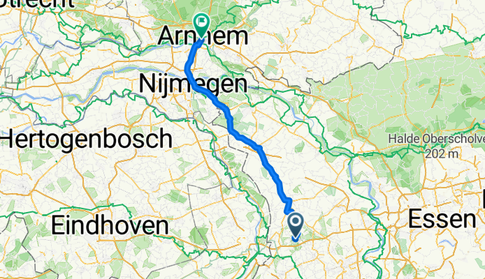
Wachtendonk - Arnheim
A cycling route starting in Wachtendonk, North Rhine-Westphalia, Germany.
Overview
About this route
- 4 h 54 min
- Duration
- 86.7 km
- Distance
- 178 m
- Ascent
- 193 m
- Descent
- 17.7 km/h
- Avg. speed
- 60 m
- Max. altitude
Part of
Route quality
Waytypes & surfaces along the route
Waytypes
Path
56.3 km
(65 %)
Cycleway
20.8 km
(24 %)
Surfaces
Paved
74.5 km
(86 %)
Asphalt
68.5 km
(79 %)
Paved (undefined)
6.1 km
(7 %)
Undefined
12.1 km
(14 %)
Continue with Bikemap
Use, edit, or download this cycling route
You would like to ride Wachtendonk - Arnheim or customize it for your own trip? Here is what you can do with this Bikemap route:
Free features
- Save this route as favorite or in collections
- Copy & plan your own version of this route
- Split it into stages to create a multi-day tour
- Sync your route with Garmin or Wahoo
Premium features
Free trial for 3 days, or one-time payment. More about Bikemap Premium.
- Navigate this route on iOS & Android
- Export a GPX / KML file of this route
- Create your custom printout (try it for free)
- Download this route for offline navigation
Discover more Premium features.
Get Bikemap PremiumFrom our community
Other popular routes starting in Wachtendonk
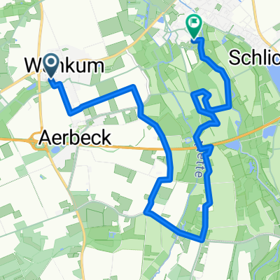 Von Wankum nach Wachtendonk auf schönen Pfaden
- Distance
- 10.7 km
- Ascent
- 8 m
- Descent
- 20 m
- Location
- Wachtendonk, North Rhine-Westphalia, Germany
 Erkelenz - Aachen
- Distance
- 36.4 km
- Ascent
- 91 m
- Descent
- 106 m
- Location
- Wachtendonk, North Rhine-Westphalia, Germany
 Wachtendonk-Krickenbeck-Lagune-Wachtendonk
- Distance
- 40.9 km
- Ascent
- 138 m
- Descent
- 138 m
- Location
- Wachtendonk, North Rhine-Westphalia, Germany
 NR576: Wachtendonk - Kempen - Grefrath - Nettetal - Wachtendonk
- Distance
- 51.4 km
- Ascent
- 91 m
- Descent
- 76 m
- Location
- Wachtendonk, North Rhine-Westphalia, Germany
 Ruta tranquila con mi Frau
- Distance
- 10.5 km
- Ascent
- 27 m
- Descent
- 22 m
- Location
- Wachtendonk, North Rhine-Westphalia, Germany
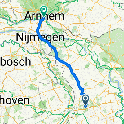 Wachtendonk - Arnheim
- Distance
- 86.7 km
- Ascent
- 178 m
- Descent
- 193 m
- Location
- Wachtendonk, North Rhine-Westphalia, Germany
 🚴🇩🇪🇳🇱🔥
- Distance
- 45.2 km
- Ascent
- 210 m
- Descent
- 211 m
- Location
- Wachtendonk, North Rhine-Westphalia, Germany
 Bürgermeister-Tour
- Distance
- 37.1 km
- Ascent
- 67 m
- Descent
- 68 m
- Location
- Wachtendonk, North Rhine-Westphalia, Germany
Open it in the app