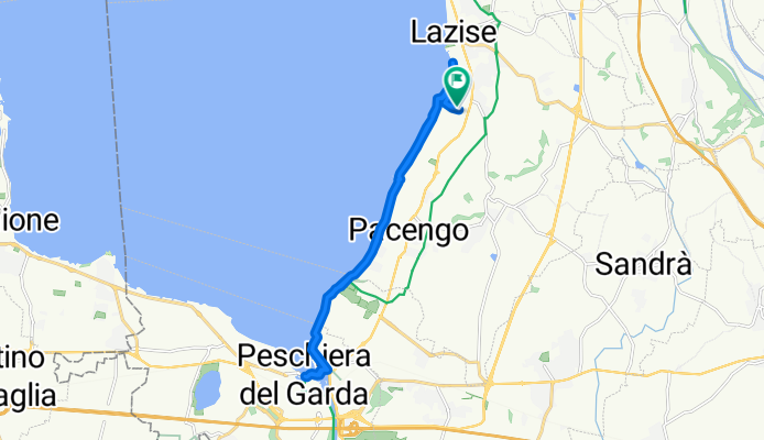
Strada Senza Nome do Strada Senza Nome
A cycling route starting in Lazise, Veneto, Italy.
Overview
About this route
- 2 h 36 min
- Duration
- 19 km
- Distance
- 68 m
- Ascent
- 116 m
- Descent
- 7.3 km/h
- Avg. speed
- 145 m
- Max. altitude
Route photos
Continue with Bikemap
Use, edit, or download this cycling route
You would like to ride Strada Senza Nome do Strada Senza Nome or customize it for your own trip? Here is what you can do with this Bikemap route:
Free features
- Save this route as favorite or in collections
- Copy & plan your own version of this route
- Sync your route with Garmin or Wahoo
Premium features
Free trial for 3 days, or one-time payment. More about Bikemap Premium.
- Navigate this route on iOS & Android
- Export a GPX / KML file of this route
- Create your custom printout (try it for free)
- Download this route for offline navigation
Discover more Premium features.
Get Bikemap PremiumFrom our community
Other popular routes starting in Lazise
da Lazise a punta san vigilio- Distance
- 12.9 km
- Ascent
- 117 m
- Descent
- 112 m
- Location
- Lazise, Veneto, Italy
Strada Senza Nome do Strada Senza Nome- Distance
- 19 km
- Ascent
- 68 m
- Descent
- 116 m
- Location
- Lazise, Veneto, Italy
Monte Baldo Training- Distance
- 71.7 km
- Ascent
- 1,206 m
- Descent
- 1,206 m
- Location
- Lazise, Veneto, Italy
Lazise nach Salo mit Fähre zurück- Distance
- 53.5 km
- Ascent
- 554 m
- Descent
- 549 m
- Location
- Lazise, Veneto, Italy
Lazise -> Gargnano - GardaRound 2/2- Distance
- 64.7 km
- Ascent
- 376 m
- Descent
- 374 m
- Location
- Lazise, Veneto, Italy
Lazise nach Via Gardesana, Castelnuovo del Garda- Distance
- 12.9 km
- Ascent
- 105 m
- Descent
- 87 m
- Location
- Lazise, Veneto, Italy
Lazise Riva del Garda- Distance
- 79.8 km
- Ascent
- 1,544 m
- Descent
- 1,540 m
- Location
- Lazise, Veneto, Italy
Gardasee_01- Distance
- 56.6 km
- Ascent
- 814 m
- Descent
- 814 m
- Location
- Lazise, Veneto, Italy
Open it in the app


