
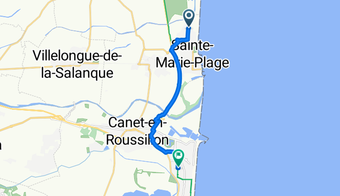
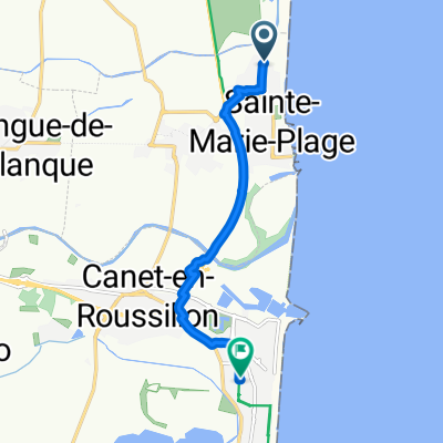
Avenue des Dunes, Sainte-Marie-la-Mer à Rue des Dahlias, Canet-en-Roussillon
A cycling route starting in Sainte-Marie-Plage, Occitanie, France.
Overview
About this route
Embark on a scenic cycling adventure from the charming town of Sainte-Marie-la-Mer to the picturesque Canet Plage in Canet-en-Roussillon. Covering a distance of 7.6 km, this route offers a delightful blend of paved paths and gentle elevation changes.
You'll start with a mix of paved and unpaved surfaces, gradually transitioning to predominantly paved routes. The ascent is modest, with a maximum elevation of just 9 meters, providing a gentle challenge for cyclists.
Throughout the journey, enjoy the tranquility of the Route tranquille, a network of peaceful paths ideal for leisurely rides. As you pedal along, take in the stunning coastal views and the rich local landscape.
This route is perfect for both seasoned cyclists and those looking for a relaxed yet invigorating ride. Enjoy the ride!
AI generated
- 26 min
- Duration
- 7.6 km
- Distance
- 8 m
- Ascent
- 6 m
- Descent
- 17.8 km/h
- Avg. speed
- 10 m
- Max. altitude
Route quality
Waytypes & surfaces along the route
Waytypes
Quiet road
3.9 km
(51 %)
Path
1.7 km
(22 %)
Surfaces
Paved
5.4 km
(71 %)
Asphalt
5 km
(66 %)
Concrete
0.4 km
(5 %)
Undefined
2.2 km
(29 %)
Continue with Bikemap
Use, edit, or download this cycling route
You would like to ride Avenue des Dunes, Sainte-Marie-la-Mer à Rue des Dahlias, Canet-en-Roussillon or customize it for your own trip? Here is what you can do with this Bikemap route:
Free features
- Save this route as favorite or in collections
- Copy & plan your own version of this route
- Sync your route with Garmin or Wahoo
Premium features
Free trial for 3 days, or one-time payment. More about Bikemap Premium.
- Navigate this route on iOS & Android
- Export a GPX / KML file of this route
- Create your custom printout (try it for free)
- Download this route for offline navigation
Discover more Premium features.
Get Bikemap PremiumFrom our community
Other popular routes starting in Sainte-Marie-Plage
 Canet 1
- Distance
- 68.2 km
- Ascent
- 303 m
- Descent
- 302 m
- Location
- Sainte-Marie-Plage, Occitanie, France
 Rondje Sainte marie
- Distance
- 18.6 km
- Ascent
- 4 m
- Descent
- 5 m
- Location
- Sainte-Marie-Plage, Occitanie, France
 AAA Pyrenäen-Durchquerung 2016
- Distance
- 820.9 km
- Ascent
- 11,053 m
- Descent
- 11,027 m
- Location
- Sainte-Marie-Plage, Occitanie, France
 2011 Pyre1
- Distance
- 139.7 km
- Ascent
- 1,634 m
- Descent
- 1,569 m
- Location
- Sainte-Marie-Plage, Occitanie, France
 stuur Marie rivier la agly rivesaltes pia bompas camping staat marie
- Distance
- 42.7 km
- Ascent
- 45 m
- Descent
- 43 m
- Location
- Sainte-Marie-Plage, Occitanie, France
 Avenue des Dunes, Sainte-Marie-la-Mer à Rue des Dahlias, Canet-en-Roussillon
- Distance
- 7.6 km
- Ascent
- 8 m
- Descent
- 6 m
- Location
- Sainte-Marie-Plage, Occitanie, France
 De Les Illes 1443, Sainte-Marie-la-Mer a Chemin du maritime, Narbonne
- Distance
- 61.3 km
- Ascent
- 102 m
- Descent
- 98 m
- Location
- Sainte-Marie-Plage, Occitanie, France
 Brasilia camping - st. cyprien
- Distance
- 10.7 km
- Ascent
- 6 m
- Descent
- 10 m
- Location
- Sainte-Marie-Plage, Occitanie, France
Open it in the app