
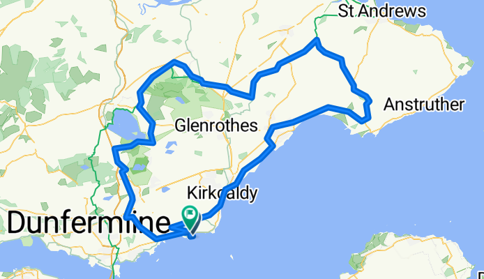
Tour of the Kingdom Ride 130km route
A cycling route starting in Burntisland, Scotland, United Kingdom.
Overview
About this route
Tour of the Kingdom Ride circular (clockwise) route - 130km route follows 73k route until east end of Loch Leven, then left for Scotlandwell, Kinnesswood, Wester Balgedie, then Dryside Road to Strathmiglo, Flakland, Freuchie, across A914 to left turn for Burnturk at Drummy Wood, on to Cults, Chance Inn, Craigrothie, Ceres, Pitscottie, Kilconquhar,, right onto A917, Largo, Lundin Links, Scoonie, Windygates roundabout, left for Muiredge (Buckhaven), East Wemyss, Coaltown, Dysart, Ravenscraig, Kirkcaldy Esplanade, Invertiel and left onto Jawbane Road under railway bridge. Then same route as for 73km route.
Enjoy!!
- -:--
- Duration
- 129 km
- Distance
- 792 m
- Ascent
- 774 m
- Descent
- ---
- Avg. speed
- ---
- Max. altitude
Route quality
Waytypes & surfaces along the route
Waytypes
Busy road
78.2 km
(61 %)
Quiet road
33.5 km
(26 %)
Surfaces
Paved
69.5 km
(54 %)
Unpaved
0.4 km
(<1 %)
Asphalt
69.2 km
(54 %)
Unpaved (undefined)
0.4 km
(<1 %)
Continue with Bikemap
Use, edit, or download this cycling route
You would like to ride Tour of the Kingdom Ride 130km route or customize it for your own trip? Here is what you can do with this Bikemap route:
Free features
- Save this route as favorite or in collections
- Copy & plan your own version of this route
- Split it into stages to create a multi-day tour
- Sync your route with Garmin or Wahoo
Premium features
Free trial for 3 days, or one-time payment. More about Bikemap Premium.
- Navigate this route on iOS & Android
- Export a GPX / KML file of this route
- Create your custom printout (try it for free)
- Download this route for offline navigation
Discover more Premium features.
Get Bikemap PremiumFrom our community
Other popular routes starting in Burntisland
 Tour of the Kingdom Ride 130km route
- Distance
- 129 km
- Ascent
- 792 m
- Descent
- 774 m
- Location
- Burntisland, Scotland, United Kingdom
 School 2
- Distance
- 5.3 km
- Ascent
- 82 m
- Descent
- 89 m
- Location
- Burntisland, Scotland, United Kingdom
 BIsCupar
- Distance
- 47.3 km
- Ascent
- 369 m
- Descent
- 354 m
- Location
- Burntisland, Scotland, United Kingdom
 Lengthy bike tour from カーコーディー to セントアンドリューズ
- Distance
- 52.2 km
- Ascent
- 390 m
- Descent
- 492 m
- Location
- Burntisland, Scotland, United Kingdom
 BislLeuc
- Distance
- 59.8 km
- Ascent
- 429 m
- Descent
- 418 m
- Location
- Burntisland, Scotland, United Kingdom
 St Margaret's Way-Burntisland to Leven
- Distance
- 23.8 km
- Ascent
- 126 m
- Descent
- 119 m
- Location
- Burntisland, Scotland, United Kingdom
 InvkLeuc
- Distance
- 60.7 km
- Ascent
- 464 m
- Descent
- 465 m
- Location
- Burntisland, Scotland, United Kingdom
Open it in the app