
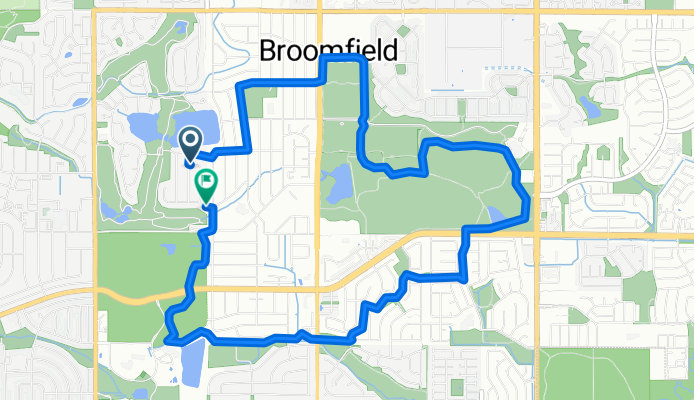
Par Rd, Broomfield to Par Rd, Broomfield
A cycling route starting in Broomfield, Colorado, United States.
Overview
About this route
- 41 min
- Duration
- 10 km
- Distance
- 47 m
- Ascent
- 47 m
- Descent
- 14.7 km/h
- Avg. speed
- 1,645 m
- Max. altitude

Route quality
Waytypes & surfaces along the route
Waytypes
Path
6.7 km
(67 %)
Quiet road
2.7 km
(27 %)
Surfaces
Paved
4.6 km
(46 %)
Unpaved
2.8 km
(28 %)
Paved (undefined)
4 km
(40 %)
Unpaved (undefined)
1.6 km
(16 %)
Continue with Bikemap
Use, edit, or download this cycling route
You would like to ride Par Rd, Broomfield to Par Rd, Broomfield or customize it for your own trip? Here is what you can do with this Bikemap route:
Free features
- Save this route as favorite or in collections
- Copy & plan your own version of this route
- Sync your route with Garmin or Wahoo
Premium features
Free trial for 3 days, or one-time payment. More about Bikemap Premium.
- Navigate this route on iOS & Android
- Export a GPX / KML file of this route
- Create your custom printout (try it for free)
- Download this route for offline navigation
Discover more Premium features.
Get Bikemap PremiumFrom our community
Other popular routes starting in Broomfield
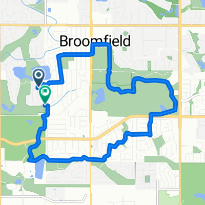 Par Rd, Broomfield to Par Rd, Broomfield
- Distance
- 10 km
- Ascent
- 47 m
- Descent
- 47 m
- Location
- Broomfield, Colorado, United States
 East 3rd Avenue 930, Broomfield to East 3rd Avenue 930, Broomfield
- Distance
- 38.1 km
- Ascent
- 365 m
- Descent
- 366 m
- Location
- Broomfield, Colorado, United States
 763 Eldorado Blvd, Broomfield to 763 Eldorado Blvd, Broomfield
- Distance
- 8.9 km
- Ascent
- 103 m
- Descent
- 104 m
- Location
- Broomfield, Colorado, United States
 Big Dry Creek Trail (Westminster)
- Distance
- 9.7 km
- Ascent
- 92 m
- Descent
- 6 m
- Location
- Broomfield, Colorado, United States
 Jersey mikes
- Distance
- 4.2 km
- Ascent
- 17 m
- Descent
- 27 m
- Location
- Broomfield, Colorado, United States
 - RTD Buses Only
- Distance
- 12.5 km
- Ascent
- 120 m
- Descent
- 93 m
- Location
- Broomfield, Colorado, United States
 W 121st Ave, Broomfield to W 165th Ln, Broomfield
- Distance
- 12.5 km
- Ascent
- 55 m
- Descent
- 47 m
- Location
- Broomfield, Colorado, United States
 YayClay!
- Distance
- 29.1 km
- Ascent
- 154 m
- Descent
- 188 m
- Location
- Broomfield, Colorado, United States
Open it in the app