
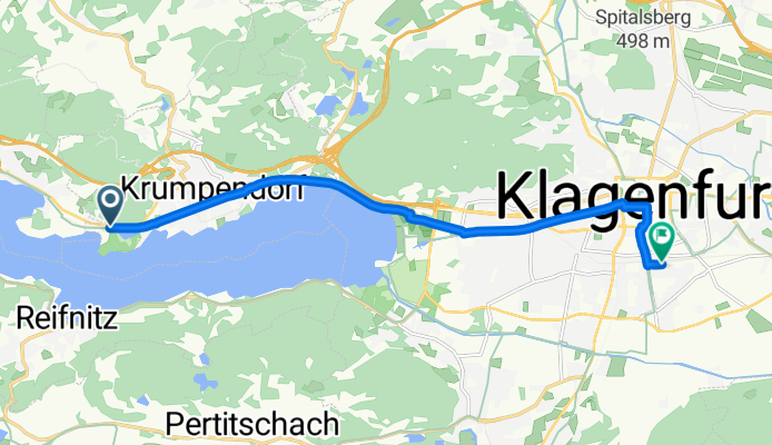
Klagenfurt hbf
A cycling route starting in Maria Wörth, Carinthia, Austria.
Overview
About this route
- 39 min
- Duration
- 11.1 km
- Distance
- 28 m
- Ascent
- 34 m
- Descent
- 17.3 km/h
- Avg. speed
- 453 m
- Max. altitude
Route quality
Waytypes & surfaces along the route
Waytypes
Quiet road
6.6 km
(59 %)
Cycleway
4.2 km
(38 %)
Surfaces
Paved
10.7 km
(96 %)
Unpaved
0.1 km
(1 %)
Asphalt
10.7 km
(96 %)
Gravel
0.1 km
(1 %)
Undefined
0.3 km
(3 %)
Continue with Bikemap
Use, edit, or download this cycling route
You would like to ride Klagenfurt hbf or customize it for your own trip? Here is what you can do with this Bikemap route:
Free features
- Save this route as favorite or in collections
- Copy & plan your own version of this route
- Sync your route with Garmin or Wahoo
Premium features
Free trial for 3 days, or one-time payment. More about Bikemap Premium.
- Navigate this route on iOS & Android
- Export a GPX / KML file of this route
- Create your custom printout (try it for free)
- Download this route for offline navigation
Discover more Premium features.
Get Bikemap PremiumFrom our community
Other popular routes starting in Maria Wörth
 Dellach-Pyramidenkegel
- Distance
- 14.6 km
- Ascent
- 501 m
- Descent
- 499 m
- Location
- Maria Wörth, Carinthia, Austria
 dokoła Worthersee
- Distance
- 41.5 km
- Ascent
- 212 m
- Descent
- 212 m
- Location
- Maria Wörth, Carinthia, Austria
 Wörth-Hoher Galien
- Distance
- 47.7 km
- Ascent
- 798 m
- Descent
- 799 m
- Location
- Maria Wörth, Carinthia, Austria
 Um den See und auf den Kogel CLONED FROM ROUTE 274685
- Distance
- 49.8 km
- Ascent
- 519 m
- Descent
- 520 m
- Location
- Maria Wörth, Carinthia, Austria
 zum Faaker -Insel
- Distance
- 22.4 km
- Ascent
- 237 m
- Descent
- 126 m
- Location
- Maria Wörth, Carinthia, Austria
 Mit'n Radl aufn PyramiedenKogel
- Distance
- 21.1 km
- Ascent
- 486 m
- Descent
- 119 m
- Location
- Maria Wörth, Carinthia, Austria
 Draurunde
- Distance
- 55.2 km
- Ascent
- 365 m
- Descent
- 366 m
- Location
- Maria Wörth, Carinthia, Austria
 Um den See und auf den Kogel
- Distance
- 49.8 km
- Ascent
- 721 m
- Descent
- 681 m
- Location
- Maria Wörth, Carinthia, Austria
Open it in the app