
Chemin de Ricazouls nach Chemin de Ricazouls
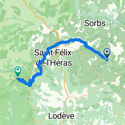
A cycling route starting in Lodève, Occitanie, France.
Overview
About this route
- 3 h 34 min
- Duration
- 32.1 km
- Distance
- 417 m
- Ascent
- 448 m
- Descent
- 9 km/h
- Avg. speed
- 232 m
- Max. altitude

Route quality
Waytypes & surfaces along the route
Waytypes
Quiet road
12.9 km
(40 %)
Road
10 km
(31 %)
Surfaces
Paved
12.9 km
(40 %)
Unpaved
8 km
(25 %)
Asphalt
11.6 km
(36 %)
Gravel
4.8 km
(15 %)
Continue with Bikemap
Use, edit, or download this cycling route
You would like to ride Chemin de Ricazouls nach Chemin de Ricazouls or customize it for your own trip? Here is what you can do with this Bikemap route:
Free features
- Save this route as favorite or in collections
- Copy & plan your own version of this route
- Sync your route with Garmin or Wahoo
Premium features
Free trial for 3 days, or one-time payment. More about Bikemap Premium.
- Navigate this route on iOS & Android
- Export a GPX / KML file of this route
- Create your custom printout (try it for free)
- Download this route for offline navigation
Discover more Premium features.
Get Bikemap PremiumFrom our community
Other popular routes starting in Lodève
 Hérault 2010 - 05
- Distance
- 51.1 km
- Ascent
- 910 m
- Descent
- 906 m
- Location
- Lodève, Occitanie, France
 fozieres
- Distance
- 19.1 km
- Ascent
- 310 m
- Descent
- 310 m
- Location
- Lodève, Occitanie, France
 Ride Day 24—5 Oct 2005—34700 Lodève to 30270 St Jean-du-Gard
- Distance
- 90.8 km
- Ascent
- 844 m
- Descent
- 817 m
- Location
- Lodève, Occitanie, France
 Etape 10 – Du Col de Roube à Dio-et-Valquières
- Distance
- 13.3 km
- Ascent
- 337 m
- Descent
- 384 m
- Location
- Lodève, Occitanie, France
 2021 D 493 um La Bastide du Font
- Distance
- 12.4 km
- Ascent
- 177 m
- Descent
- 176 m
- Location
- Lodève, Occitanie, France
 Etape 08 – De La Vernède à Roqueredonde
- Distance
- 30 km
- Ascent
- 510 m
- Descent
- 521 m
- Location
- Lodève, Occitanie, France
 TdfC 31k Lac Salagou
- Distance
- 30.9 km
- Ascent
- 466 m
- Descent
- 467 m
- Location
- Lodève, Occitanie, France
 2021 D 142 Runde bis Mas Gauzin
- Distance
- 11.5 km
- Ascent
- 182 m
- Descent
- 150 m
- Location
- Lodève, Occitanie, France
Open it in the app