
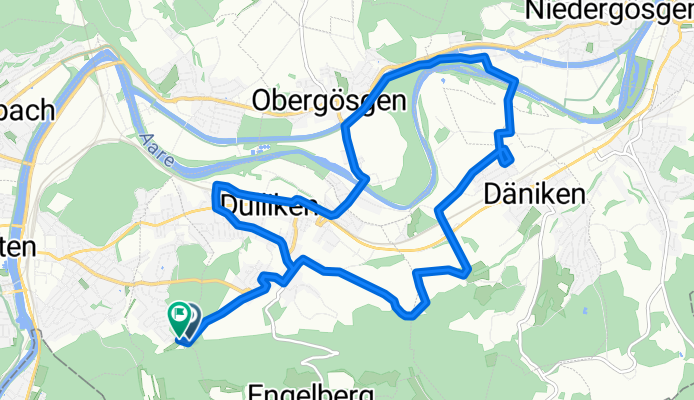
Kohliweidstrasse, Starrkirch-Wil nach Säliring, Starrkirch-Wil
A cycling route starting in Olten, Canton of Solothurn, Switzerland.
Overview
About this route
Embark on an exhilarating 15.8 km cycling adventure that will test your stamina and reward you with breathtaking views. Begin your journey and ascend 144 meters, gradually building your strength as you approach the highest point at 496 meters. The route features a gentle descent of 146 meters, providing a thrilling change of pace. Enjoy the diverse terrain that keeps the ride engaging and exciting.
AI generated
- 39 min
- Duration
- 15.8 km
- Distance
- 145 m
- Ascent
- 146 m
- Descent
- 24.4 km/h
- Avg. speed
- 497 m
- Max. altitude
Route quality
Waytypes & surfaces along the route
Waytypes
Quiet road
9.2 km
(58 %)
Track
2.9 km
(18 %)
Surfaces
Paved
5.2 km
(33 %)
Unpaved
2.9 km
(18 %)
Asphalt
5.2 km
(33 %)
Gravel
2.9 km
(18 %)
Undefined
7.8 km
(49 %)
Continue with Bikemap
Use, edit, or download this cycling route
You would like to ride Kohliweidstrasse, Starrkirch-Wil nach Säliring, Starrkirch-Wil or customize it for your own trip? Here is what you can do with this Bikemap route:
Free features
- Save this route as favorite or in collections
- Copy & plan your own version of this route
- Sync your route with Garmin or Wahoo
Premium features
Free trial for 3 days, or one-time payment. More about Bikemap Premium.
- Navigate this route on iOS & Android
- Export a GPX / KML file of this route
- Create your custom printout (try it for free)
- Download this route for offline navigation
Discover more Premium features.
Get Bikemap PremiumFrom our community
Other popular routes starting in Olten
 Route nach Hergiswil (Nidwalden)
- Distance
- 193 km
- Ascent
- 4,900 m
- Descent
- 4,857 m
- Location
- Olten, Canton of Solothurn, Switzerland
 Grenchenberg Corcelles Schelten
- Distance
- 149 km
- Ascent
- 2,318 m
- Descent
- 2,318 m
- Location
- Olten, Canton of Solothurn, Switzerland
 Kohliweidstrasse, Starrkirch-Wil nach Säliring, Starrkirch-Wil
- Distance
- 15.8 km
- Ascent
- 145 m
- Descent
- 146 m
- Location
- Olten, Canton of Solothurn, Switzerland
 Schützenmattweg 12, Olten nach Forstackerstrasse 4F, Zofingen
- Distance
- 10 km
- Ascent
- 84 m
- Descent
- 38 m
- Location
- Olten, Canton of Solothurn, Switzerland
 Säliring, Starrkirch-Wil nach Säliring, Starrkirch-Wil
- Distance
- 16 km
- Ascent
- 142 m
- Descent
- 144 m
- Location
- Olten, Canton of Solothurn, Switzerland
 Säliring, Starrkirch-Wil nach Säliring, Starrkirch-Wil
- Distance
- 13.4 km
- Ascent
- 124 m
- Descent
- 124 m
- Location
- Olten, Canton of Solothurn, Switzerland
 Säliring, Starrkirch-Wil nach Säliring, Starrkirch-Wil
- Distance
- 25.6 km
- Ascent
- 241 m
- Descent
- 243 m
- Location
- Olten, Canton of Solothurn, Switzerland
 Säliring, Starrkirch-Wil nach Säliring, Starrkirch-Wil
- Distance
- 25.7 km
- Ascent
- 250 m
- Descent
- 251 m
- Location
- Olten, Canton of Solothurn, Switzerland
Open it in the app