

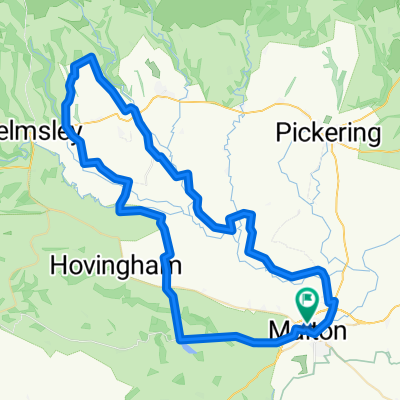
Malton Cycling
A cycling route starting in Malton, England, United Kingdom.
Overview
About this route
EDGE 1040®
- 2 h 21 min
- Duration
- 58.3 km
- Distance
- 380 m
- Ascent
- 380 m
- Descent
- 24.8 km/h
- Avg. speed
- 122 m
- Max. altitude
Paul Welsh

created this 3 months ago
Route quality
Waytypes & surfaces along the route
Waytypes
Road
35.5 km
(61 %)
Quiet road
19.2 km
(33 %)
Surfaces
Paved
30.9 km
(53 %)
Asphalt
30.9 km
(53 %)
Undefined
27.4 km
(47 %)
Continue with Bikemap
Use, edit, or download this cycling route
You would like to ride Malton Cycling or customize it for your own trip? Here is what you can do with this Bikemap route:
Free features
- Save this route as favorite or in collections
- Copy & plan your own version of this route
- Sync your route with Garmin or Wahoo
Premium features
Free trial for 3 days, or one-time payment. More about Bikemap Premium.
- Navigate this route on iOS & Android
- Export a GPX / KML file of this route
- Create your custom printout (try it for free)
- Download this route for offline navigation
Discover more Premium features.
Get Bikemap PremiumFrom our community
Other popular routes starting in Malton
- Newbiggin to Hutton Beverley Road
- 43 km
- 476 m
- 497 m
- Malton, England, United Kingdom
- Field Close to Lighthouse Road
- 58.9 km
- 455 m
- 448 m
- Malton, England, United Kingdom
- Malton 010920 - 28.2m
- 45.6 km
- 429 m
- 428 m
- Malton, England, United Kingdom


Open it in the app