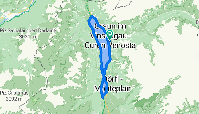
Umrundung Reschensee und Heidersee
A cycling route starting in Graun im Vinschgau, Trentino-Alto Adige, Italy.
Overview
About this route
- 1 h 54 min
- Duration
- 24.9 km
- Distance
- 234 m
- Ascent
- 229 m
- Descent
- 13.2 km/h
- Avg. speed
- 1,536 m
- Max. altitude
Route photos
Route quality
Waytypes & surfaces along the route
Waytypes
Quiet road
9 km
(36 %)
Track
8.5 km
(34 %)
Surfaces
Paved
18.2 km
(73 %)
Unpaved
6.2 km
(25 %)
Asphalt
18.2 km
(73 %)
Loose gravel
5.5 km
(22 %)
Continue with Bikemap
Use, edit, or download this cycling route
You would like to ride Umrundung Reschensee und Heidersee or customize it for your own trip? Here is what you can do with this Bikemap route:
Free features
- Save this route as favorite or in collections
- Copy & plan your own version of this route
- Sync your route with Garmin or Wahoo
Premium features
Free trial for 3 days, or one-time payment. More about Bikemap Premium.
- Navigate this route on iOS & Android
- Export a GPX / KML file of this route
- Create your custom printout (try it for free)
- Download this route for offline navigation
Discover more Premium features.
Get Bikemap PremiumFrom our community
Other popular routes starting in Graun im Vinschgau
Runde - Reschensee und Heidersee mit lecker Stopp beim Zenner- Distance
- 22.6 km
- Ascent
- 216 m
- Descent
- 212 m
- Location
- Graun im Vinschgau, Trentino-Alto Adige, Italy
Via Paese Vecchio - Waldbodenweg- Distance
- 18.3 km
- Ascent
- 125 m
- Descent
- 137 m
- Location
- Graun im Vinschgau, Trentino-Alto Adige, Italy
Tag 5: Bergab durch Südtirol- Distance
- 122.6 km
- Ascent
- 310 m
- Descent
- 1,609 m
- Location
- Graun im Vinschgau, Trentino-Alto Adige, Italy
02 Schöneben - Prad- Distance
- 36.2 km
- Ascent
- 446 m
- Descent
- 1,649 m
- Location
- Graun im Vinschgau, Trentino-Alto Adige, Italy
Reschen - Meran- Distance
- 73.2 km
- Ascent
- 619 m
- Descent
- 1,744 m
- Location
- Graun im Vinschgau, Trentino-Alto Adige, Italy
Reg.Reschensee-Obervinschgau - Meran- Distance
- 73.5 km
- Ascent
- 467 m
- Descent
- 1,626 m
- Location
- Graun im Vinschgau, Trentino-Alto Adige, Italy
Melag bis Moseben und zurück mit Gravelbike- Distance
- 23.6 km
- Ascent
- 689 m
- Descent
- 697 m
- Location
- Graun im Vinschgau, Trentino-Alto Adige, Italy
leg 2 final- Distance
- 196.3 km
- Ascent
- 1,074 m
- Descent
- 2,384 m
- Location
- Graun im Vinschgau, Trentino-Alto Adige, Italy
Open it in the app


