
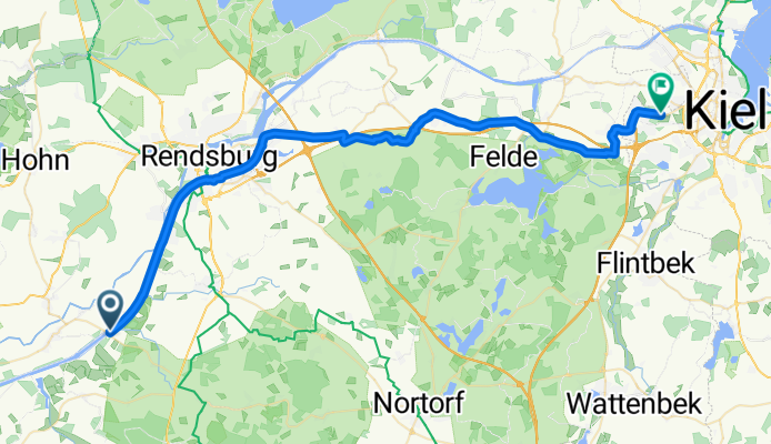
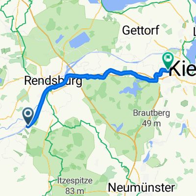
Breiholz Kiel
A cycling route starting in Hörsten, Schleswig-Holstein, Germany.
Overview
About this route
- 2 h 38 min
- Duration
- 45 km
- Distance
- 155 m
- Ascent
- 135 m
- Descent
- 17.1 km/h
- Avg. speed
- 40 m
- Max. altitude

Route quality
Waytypes & surfaces along the route
Waytypes
Path
21.6 km
(48 %)
Track
14.4 km
(32 %)
Surfaces
Paved
42.7 km
(95 %)
Asphalt
26.1 km
(58 %)
Concrete
14.4 km
(32 %)
Continue with Bikemap
Use, edit, or download this cycling route
You would like to ride Breiholz Kiel or customize it for your own trip? Here is what you can do with this Bikemap route:
Free features
- Save this route as favorite or in collections
- Copy & plan your own version of this route
- Sync your route with Garmin or Wahoo
Premium features
Free trial for 3 days, or one-time payment. More about Bikemap Premium.
- Navigate this route on iOS & Android
- Export a GPX / KML file of this route
- Create your custom printout (try it for free)
- Download this route for offline navigation
Discover more Premium features.
Get Bikemap PremiumFrom our community
Other popular routes starting in Hörsten
 Breiholz bis SP Flugplatz Schachtholm
- Distance
- 22 km
- Ascent
- 12 m
- Descent
- 12 m
- Location
- Hörsten, Schleswig-Holstein, Germany
 K27, Hörsten nach K27, Hörsten
- Distance
- 25.2 km
- Ascent
- 309 m
- Descent
- 312 m
- Location
- Hörsten, Schleswig-Holstein, Germany
 NOK-Tour 02
- Distance
- 34.3 km
- Ascent
- 56 m
- Descent
- 56 m
- Location
- Hörsten, Schleswig-Holstein, Germany
 Breiholz Kiel
- Distance
- 45 km
- Ascent
- 155 m
- Descent
- 135 m
- Location
- Hörsten, Schleswig-Holstein, Germany
 NOK Route
- Distance
- 42.6 km
- Ascent
- 91 m
- Descent
- 91 m
- Location
- Hörsten, Schleswig-Holstein, Germany
 Grünental Brücke über Fischerhütte
- Distance
- 25.6 km
- Ascent
- 44 m
- Descent
- 16 m
- Location
- Hörsten, Schleswig-Holstein, Germany
 K47, Hörsten nach Hohe Straße 3, Hohn
- Distance
- 14.5 km
- Ascent
- 40 m
- Descent
- 28 m
- Location
- Hörsten, Schleswig-Holstein, Germany
 NOK - Schachtholm-Brunsbüttel und retour
- Distance
- 105.5 km
- Ascent
- 30 m
- Descent
- 30 m
- Location
- Hörsten, Schleswig-Holstein, Germany
Open it in the app