
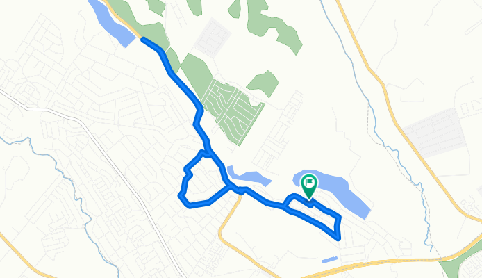
mugutha - kiganjo
A cycling route starting in Thika, Nairobi County, Kenya.
Overview
About this route
- 2 h 27 min
- Duration
- 13.3 km
- Distance
- 166 m
- Ascent
- 146 m
- Descent
- 5.4 km/h
- Avg. speed
- 1,543 m
- Max. altitude

Route photos


Continue with Bikemap
Use, edit, or download this cycling route
You would like to ride mugutha - kiganjo or customize it for your own trip? Here is what you can do with this Bikemap route:
Free features
- Save this route as favorite or in collections
- Copy & plan your own version of this route
- Sync your route with Garmin or Wahoo
Premium features
Free trial for 3 days, or one-time payment. More about Bikemap Premium.
- Navigate this route on iOS & Android
- Export a GPX / KML file of this route
- Create your custom printout (try it for free)
- Download this route for offline navigation
Discover more Premium features.
Get Bikemap PremiumFrom our community
Other popular routes starting in Thika
 Slow ride
- Distance
- 34.3 km
- Ascent
- 376 m
- Descent
- 341 m
- Location
- Thika, Nairobi County, Kenya
 Juja Mall, Kalimoni to Eastern By Pass, Ruiru
- Distance
- 162 km
- Ascent
- 725 m
- Descent
- 700 m
- Location
- Thika, Nairobi County, Kenya
 mugutha - kiganjo
- Distance
- 13.3 km
- Ascent
- 166 m
- Descent
- 146 m
- Location
- Thika, Nairobi County, Kenya
 V2V9+XJM, Juja to V2W7+2VC, Juja
- Distance
- 9.9 km
- Ascent
- 55 m
- Descent
- 41 m
- Location
- Thika, Nairobi County, Kenya
 Slow ride
- Distance
- 3.8 km
- Ascent
- 27 m
- Descent
- 15 m
- Location
- Thika, Nairobi County, Kenya
 Planned - Trial under 2hrs.
- Distance
- 52.2 km
- Ascent
- 500 m
- Descent
- 501 m
- Location
- Thika, Nairobi County, Kenya
 Unnamed Road, Juja to Unnamed Road, Juja
- Distance
- 12.8 km
- Ascent
- 46 m
- Descent
- 51 m
- Location
- Thika, Nairobi County, Kenya
 Cracking ride
- Distance
- 38.9 km
- Ascent
- 303 m
- Descent
- 296 m
- Location
- Thika, Nairobi County, Kenya
Open it in the app