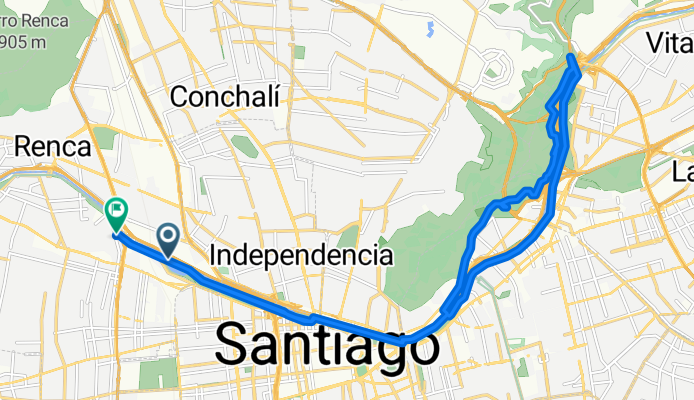
Avenida Costanera Sur, Quinta Normal a Aviador Bleriot, Quinta Normal
A cycling route starting in Lo Prado, Santiago Metropolitan, Chile.
Overview
About this route
- 1 h 25 min
- Duration
- 25.5 km
- Distance
- 283 m
- Ascent
- 292 m
- Descent
- 18.1 km/h
- Avg. speed
- 690 m
- Max. altitude
Continue with Bikemap
Use, edit, or download this cycling route
You would like to ride Avenida Costanera Sur, Quinta Normal a Aviador Bleriot, Quinta Normal or customize it for your own trip? Here is what you can do with this Bikemap route:
Free features
- Save this route as favorite or in collections
- Copy & plan your own version of this route
- Sync your route with Garmin or Wahoo
Premium features
Free trial for 3 days, or one-time payment. More about Bikemap Premium.
- Navigate this route on iOS & Android
- Export a GPX / KML file of this route
- Create your custom printout (try it for free)
- Download this route for offline navigation
Discover more Premium features.
Get Bikemap PremiumFrom our community
Other popular routes starting in Lo Prado
Pasaje Choico, Maipú a Pasaje Choico, Maipú- Distance
- 21.7 km
- Ascent
- 107 m
- Descent
- 106 m
- Location
- Lo Prado, Santiago Metropolitan, Chile
aburrimiento- Distance
- 13 km
- Ascent
- 109 m
- Descent
- 112 m
- Location
- Lo Prado, Santiago Metropolitan, Chile
ruta hacia Laguna Piedra Roja- Distance
- 40.1 km
- Ascent
- 538 m
- Descent
- 525 m
- Location
- Lo Prado, Santiago Metropolitan, Chile
De PI1656-Avenida Aeropuerto / Esq. Av. A. Vespucio, Cerrillos a Poiguano 10925, La Pintana- Distance
- 13.8 km
- Ascent
- 314 m
- Descent
- 218 m
- Location
- Lo Prado, Santiago Metropolitan, Chile
26agost ida- Distance
- 13.9 km
- Ascent
- 661 m
- Descent
- 392 m
- Location
- Lo Prado, Santiago Metropolitan, Chile
Avenida Las Torres, Quilicura a Avenida Chesterton, Las Condes- Distance
- 25.3 km
- Ascent
- 296 m
- Descent
- 81 m
- Location
- Lo Prado, Santiago Metropolitan, Chile
hasta entrada al cerro- Distance
- 17.9 km
- Ascent
- 315 m
- Descent
- 153 m
- Location
- Lo Prado, Santiago Metropolitan, Chile
Ruta desde Calle Titán- Distance
- 14.3 km
- Ascent
- 229 m
- Descent
- 115 m
- Location
- Lo Prado, Santiago Metropolitan, Chile
Open it in the app


