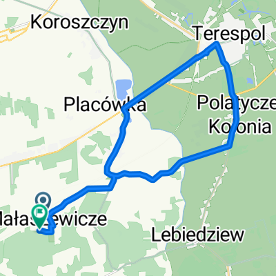
II Rajd Rowerowy MTB (IPA)
A cycling route starting in Terespol, Lublin Voivodeship, Poland.
Overview
About this route
The route starts in Koroszczyn near the GOK. The attributes of the route are:
- Paved road connecting Koroszczyn with 艁obaczew,
- Beautiful areas along the Bug,
- Silence and tranquility.
The route is not one of the easiest, as it mainly follows barely visible paths. The sandy sections are also a challenge, requiring proper preparation of both bikes and the cyclists themselves.
Travel time is 2-3 hours.:)
- -:--
- Duration
- 29.5 km
- Distance
- 30 m
- Ascent
- 38 m
- Descent
- ---
- Avg. speed
- ---
- Max. altitude
Continue with Bikemap
Use, edit, or download this cycling route
You would like to ride II Rajd Rowerowy MTB (IPA) or customize it for your own trip? Here is what you can do with this Bikemap route:
Free features
- Save this route as favorite or in collections
- Copy & plan your own version of this route
- Sync your route with Garmin or Wahoo
Premium features
Free trial for 3 days, or one-time payment. More about Bikemap Premium.
- Navigate this route on iOS & Android
- Export a GPX / KML file of this route
- Create your custom printout (try it for free)
- Download this route for offline navigation
Discover more Premium features.
Get Bikemap PremiumFrom our community
Other popular routes starting in Terespol
- Wojska Polskiego 79A, Terespol do Kolejarzy 10, Ma艂aszewicze
- Distance
- 10.6 km
- Ascent
- 53 m
- Descent
- 38 m
- Location
- Terespol, Lublin Voivodeship, Poland
- pizdec
- Distance
- 140.3 km
- Ascent
- 137 m
- Descent
- 91 m
- Location
- Terespol, Lublin Voivodeship, Poland
- Dooko艂a Polski 24 dzie艅 (Terespol- Wola Uhruska)
- Distance
- 108.6 km
- Ascent
- 133 m
- Descent
- 93 m
- Location
- Terespol, Lublin Voivodeship, Poland
- Propozycja wycieczki spotkanie powyprawowe 2013
- Distance
- 76.6 km
- Ascent
- 57 m
- Descent
- 57 m
- Location
- Terespol, Lublin Voivodeship, Poland
- Terespol - Mielnik
- Distance
- 78 km
- Ascent
- 170 m
- Descent
- 166 m
- Location
- Terespol, Lublin Voivodeship, Poland
- Ma艂aszewicze - Bia艂a Podlaska
- Distance
- 29.2 km
- Ascent
- 38 m
- Descent
- 45 m
- Location
- Terespol, Lublin Voivodeship, Poland
- Podolanka do D艂uga 4, Ma艂aszewicze
- Distance
- 15.9 km
- Ascent
- 189 m
- Descent
- 194 m
- Location
- Terespol, Lublin Voivodeship, Poland
- wschodnia granica - p贸艂noc
- Distance
- 549.9 km
- Ascent
- 2,032 m
- Descent
- 2,036 m
- Location
- Terespol, Lublin Voivodeship, Poland
Open it in the app