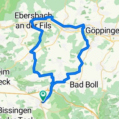
Bioshärentour 25km
A cycling route starting in Weilheim an der Teck, Baden-Württemberg, Germany.
Overview
About this route
Tour mit vielen Aussichtspunkten und Einkehrmöglichkeiten.
Auf Flurwegen meist geteert oder Schotter.
25km 250Hm.
- -:--
- Duration
- 24.4 km
- Distance
- 340 m
- Ascent
- 344 m
- Descent
- ---
- Avg. speed
- ---
- Avg. speed
Route quality
Waytypes & surfaces along the route
Waytypes
Track
14.2 km
(58 %)
Quiet road
5.4 km
(22 %)
Surfaces
Paved
12.4 km
(51 %)
Unpaved
6.9 km
(28 %)
Asphalt
7.8 km
(32 %)
Gravel
4.5 km
(19 %)
Continue with Bikemap
Use, edit, or download this cycling route
You would like to ride Bioshärentour 25km or customize it for your own trip? Here is what you can do with this Bikemap route:
Free features
- Save this route as favorite or in collections
- Copy & plan your own version of this route
- Sync your route with Garmin or Wahoo
Premium features
Free trial for 3 days, or one-time payment. More about Bikemap Premium.
- Navigate this route on iOS & Android
- Export a GPX / KML file of this route
- Create your custom printout (try it for free)
- Download this route for offline navigation
Discover more Premium features.
Get Bikemap PremiumFrom our community
Other popular routes starting in Weilheim an der Teck
- Seniorenfräd 2011 HC 02
- Distance
- 81.7 km
- Ascent
- 1,111 m
- Descent
- 1,111 m
- Location
- Weilheim an der Teck, Baden-Württemberg, Germany
- Rennrad Tour Mittwochs
- Distance
- 96.7 km
- Ascent
- 761 m
- Descent
- 760 m
- Location
- Weilheim an der Teck, Baden-Württemberg, Germany
- kleine Feierabendrunde
- Distance
- 38.4 km
- Ascent
- 532 m
- Descent
- 532 m
- Location
- Weilheim an der Teck, Baden-Württemberg, Germany
- Weilheim/Teck - Altmühlsee Etape1/3
- Distance
- 68.5 km
- Ascent
- 393 m
- Descent
- 331 m
- Location
- Weilheim an der Teck, Baden-Württemberg, Germany
- SF TdA HC 106 km
- Distance
- 105.5 km
- Ascent
- 1,244 m
- Descent
- 1,244 m
- Location
- Weilheim an der Teck, Baden-Württemberg, Germany
- Bioshärentour 25km
- Distance
- 24.4 km
- Ascent
- 340 m
- Descent
- 344 m
- Location
- Weilheim an der Teck, Baden-Württemberg, Germany
- Seniorenfräd 2011 HC 03
- Distance
- 94.2 km
- Ascent
- 1,142 m
- Descent
- 1,142 m
- Location
- Weilheim an der Teck, Baden-Württemberg, Germany
- wlhm-kirchheim
- Distance
- 51.1 km
- Ascent
- 747 m
- Descent
- 800 m
- Location
- Weilheim an der Teck, Baden-Württemberg, Germany
Open it in the app