
From Seoul to Mokpo
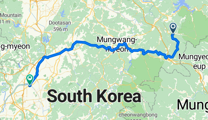
Route in Cheongju
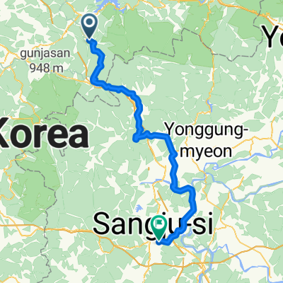
A cycling route starting in Mungyeong, Gyeongsangbuk-do, South Korea.
Overview
About this route
- 4 h 42 min
- Duration
- 83.1 km
- Distance
- 724 m
- Ascent
- 920 m
- Descent
- 17.7 km/h
- Avg. speed
- 403 m
- Max. altitude

Part of
From Seoul to Mokpo
7 stages
Route quality
Waytypes & surfaces along the route
Waytypes
Cycleway
53.2 km
(64 %)
Road
25.8 km
(31 %)
Surfaces
Paved
69 km
(83 %)
Asphalt
46.6 km
(56 %)
Concrete
15 km
(18 %)
Continue with Bikemap
Use, edit, or download this cycling route
You would like to ride Route in Cheongju or customize it for your own trip? Here is what you can do with this Bikemap route:
Free features
- Save this route as favorite or in collections
- Copy & plan your own version of this route
- Split it into stages to create a multi-day tour
- Sync your route with Garmin or Wahoo
Premium features
Free trial for 3 days, or one-time payment. More about Bikemap Premium.
- Navigate this route on iOS & Android
- Export a GPX / KML file of this route
- Create your custom printout (try it for free)
- Download this route for offline navigation
Discover more Premium features.
Get Bikemap PremiumFrom our community
Other popular routes starting in Mungyeong
 Suanbo to Mungyeong
- Distance
- 57.8 km
- Ascent
- 1,738 m
- Descent
- 1,855 m
- Location
- Mungyeong, Gyeongsangbuk-do, South Korea
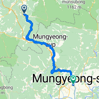
 Mungyeong - Sangju
- Distance
- 68.2 km
- Ascent
- 1,021 m
- Descent
- 1,276 m
- Location
- Mungyeong, Gyeongsangbuk-do, South Korea
 수안보면 446−7, 충주시 to 수안보면 279−9, 충주시
- Distance
- 98.4 km
- Ascent
- 1,164 m
- Descent
- 1,174 m
- Location
- Mungyeong, Gyeongsangbuk-do, South Korea
 韓国縦走サイクリング5日目(水安堡→楊平)
- Distance
- 148.9 km
- Ascent
- 300 m
- Descent
- 459 m
- Location
- Mungyeong, Gyeongsangbuk-do, South Korea
 Route in Cheongju
- Distance
- 83.1 km
- Ascent
- 724 m
- Descent
- 920 m
- Location
- Mungyeong, Gyeongsangbuk-do, South Korea
 hotel
hotel- Distance
- 26.3 km
- Ascent
- 227 m
- Descent
- 307 m
- Location
- Mungyeong, Gyeongsangbuk-do, South Korea
 3일차 여행
- Distance
- 88.7 km
- Ascent
- 2,005 m
- Descent
- 2,149 m
- Location
- Mungyeong, Gyeongsangbuk-do, South Korea
 이화령로, 문경시에서 불정동, 문경시까지
- Distance
- 22.1 km
- Ascent
- 64 m
- Descent
- 492 m
- Location
- Mungyeong, Gyeongsangbuk-do, South Korea
Open it in the app