![3-8 3-8Ph0]으로 라우팅](/_next/static/media/contour-lines-light-small.cafd5e5d.avif)
![3-8 3-8Ph0]으로 라우팅](https://media.bikemap.net/routes/17573029/staticmaps/in_1e9486e5-28b1-4458-ba8f-8607b27b1aed_694x400_bikemap-2021-3D-static.png)
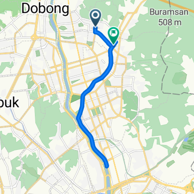
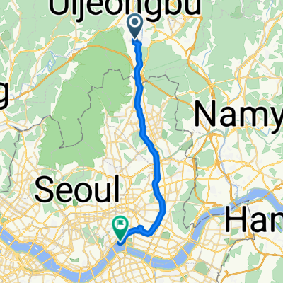
3-8 3-8Ph0]으로 라우팅
A cycling route starting in Uijeongbu-si, Gyeonggi-do, South Korea.
Overview
About this route
- 1 h 12 min
- Duration
- 23.3 km
- Distance
- 67 m
- Ascent
- 134 m
- Descent
- 19.4 km/h
- Avg. speed
- 85 m
- Max. altitude

Route quality
Waytypes & surfaces along the route
Waytypes
Cycleway
20.5 km
(88 %)
Quiet road
1.4 km
(6 %)
Surfaces
Paved
20.5 km
(88 %)
Asphalt
20.5 km
(88 %)
Undefined
2.8 km
(12 %)
Continue with Bikemap
Use, edit, or download this cycling route
You would like to ride 3-8 3-8Ph0]으로 라우팅 or customize it for your own trip? Here is what you can do with this Bikemap route:
Free features
- Save this route as favorite or in collections
- Copy & plan your own version of this route
- Sync your route with Garmin or Wahoo
Premium features
Free trial for 3 days, or one-time payment. More about Bikemap Premium.
- Navigate this route on iOS & Android
- Export a GPX / KML file of this route
- Create your custom printout (try it for free)
- Download this route for offline navigation
Discover more Premium features.
Get Bikemap PremiumFrom our community
Other popular routes starting in Uijeongbu-si
 의정부-양주 나리공원
- Distance
- 12.3 km
- Ascent
- 94 m
- Descent
- 58 m
- Location
- Uijeongbu-si, Gyeonggi-do, South Korea
 상계동 639번지 ~ 중계동 141-93
- Distance
- 11.6 km
- Ascent
- 43 m
- Descent
- 104 m
- Location
- Uijeongbu-si, Gyeonggi-do, South Korea
 느린 주행
느린 주행- Distance
- 26.2 km
- Ascent
- 11 m
- Descent
- 56 m
- Location
- Uijeongbu-si, Gyeonggi-do, South Korea
![3-8 3-8Ph0]으로 라우팅](https://media.bikemap.net/routes/17573029/staticmaps/in_1e9486e5-28b1-4458-ba8f-8607b27b1aed_400x400_bikemap-2021-3D-static.png) 3-8 3-8Ph0]으로 라우팅
3-8 3-8Ph0]으로 라우팅- Distance
- 23.3 km
- Ascent
- 67 m
- Descent
- 134 m
- Location
- Uijeongbu-si, Gyeonggi-do, South Korea
![Ph0]에서 경로고산동 336-2](https://www.bikemap.net/media/temp/routes_gallery/8899c287-f99e-4c19-b05c-fe56fd4bf808.jpg) Ph0]에서 경로고산동 336-2
Ph0]에서 경로고산동 336-2- Distance
- 2.1 km
- Ascent
- 16 m
- Descent
- 40 m
- Location
- Uijeongbu-si, Gyeonggi-do, South Korea
![Ph0]에서 경로고산동 970-1](https://media.bikemap.net/routes/17330056/gallery/thumbs/18f85175-69a7-4350-98be-145002182f58.jpg.208x208_q80_crop.jpg) Ph0]에서 경로고산동 970-1
Ph0]에서 경로고산동 970-1- Distance
- 42.8 km
- Ascent
- 251 m
- Descent
- 335 m
- Location
- Uijeongbu-si, Gyeonggi-do, South Korea
 상계동 639번지 ~ 상계동 639번지
- Distance
- 9.3 km
- Ascent
- 129 m
- Descent
- 150 m
- Location
- Uijeongbu-si, Gyeonggi-do, South Korea
 208동 102호 ~ 상계5동 456-135
- Distance
- 12.2 km
- Ascent
- 78 m
- Descent
- 110 m
- Location
- Uijeongbu-si, Gyeonggi-do, South Korea
Open it in the app