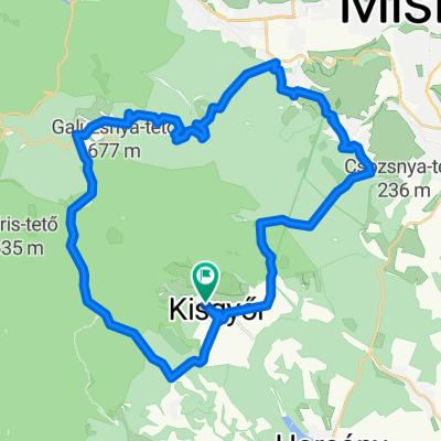
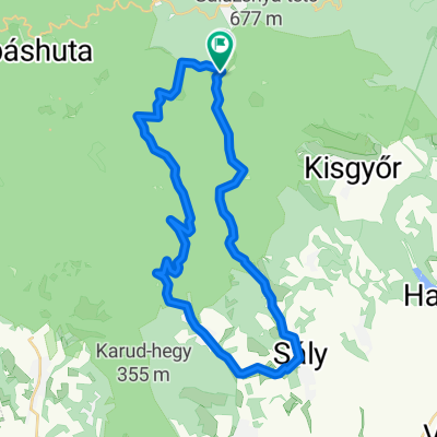
R贸kafarm - Mocsoly谩s - R贸kafarm
A cycling route starting in S谩ly, Borsod-Abauj Zemplen county, Hungary.
Overview
About this route
- 3 h 21 min
- Duration
- 31.3 km
- Distance
- 529 m
- Ascent
- 563 m
- Descent
- 9.3 km/h
- Avg. speed
- 632 m
- Max. altitude
Route photos
Route quality
Waytypes & surfaces along the route
Waytypes
Quiet road
21.6 km
(69 %)
Road
4.4 km
(14 %)
Surfaces
Paved
13.4 km
(43 %)
Asphalt
13.4 km
(43 %)
Undefined
17.8 km
(57 %)
Continue with Bikemap
Use, edit, or download this cycling route
You would like to ride R贸kafarm - Mocsoly谩s - R贸kafarm or customize it for your own trip? Here is what you can do with this Bikemap route:
Free features
- Save this route as favorite or in collections
- Copy & plan your own version of this route
- Sync your route with Garmin or Wahoo
Premium features
Free trial for 3 days, or one-time payment. More about Bikemap Premium.
- Navigate this route on iOS & Android
- Export a GPX / KML file of this route
- Create your custom printout (try it for free)
- Download this route for offline navigation
Discover more Premium features.
Get Bikemap PremiumFrom our community
Other popular routes starting in S谩ly
balatonakarttya- Distance
- 4.4 km
- Ascent
- 113 m
- Descent
- 33 m
- Location
- S谩ly, Borsod-Abauj Zemplen county, Hungary
R贸kafarm - Mocsoly谩s - R贸kafarm- Distance
- 31.3 km
- Ascent
- 529 m
- Descent
- 563 m
- Location
- S谩ly, Borsod-Abauj Zemplen county, Hungary
Dorong贸si utca - B眉kkszentkereszt- Distance
- 20.9 km
- Ascent
- 396 m
- Descent
- 455 m
- Location
- S谩ly, Borsod-Abauj Zemplen county, Hungary
V枚lgy utca - V枚lgy utca- Distance
- 43.2 km
- Ascent
- 811 m
- Descent
- 868 m
- Location
- S谩ly, Borsod-Abauj Zemplen county, Hungary
M茅rs茅kelt 煤tvonal- Distance
- 11.4 km
- Ascent
- 64 m
- Descent
- 306 m
- Location
- S谩ly, Borsod-Abauj Zemplen county, Hungary
B眉kki k枚rt煤ra 2. nap- Distance
- 109.9 km
- Ascent
- 1,453 m
- Descent
- 1,498 m
- Location
- S谩ly, Borsod-Abauj Zemplen county, Hungary
b眉kk谩br谩ny- Distance
- 24.2 km
- Ascent
- 492 m
- Descent
- 25 m
- Location
- S谩ly, Borsod-Abauj Zemplen county, Hungary
B眉kk 2016- Distance
- 88.7 km
- Ascent
- 1,208 m
- Descent
- 1,207 m
- Location
- S谩ly, Borsod-Abauj Zemplen county, Hungary
Open it in the app


