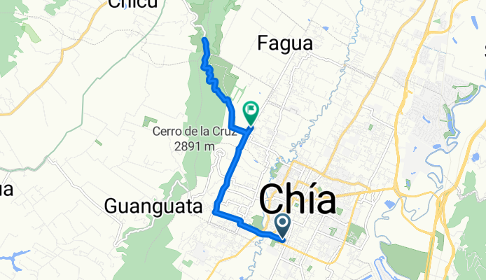
De Carrera a Via Fagua
A cycling route starting in ChÃa, Cundinamarca, Colombia.
Overview
About this route
- 1 h 33 min
- Duration
- 11.3 km
- Distance
- 134 m
- Ascent
- 146 m
- Descent
- 7.3 km/h
- Avg. speed
- 2,666 m
- Max. altitude
Route photos
Route quality
Waytypes & surfaces along the route
Waytypes
Road
10.6 km
(94 %)
Quiet road
0.3 km
(3 %)
Undefined
0.3 km
(3 %)
Surfaces
Paved
3.4 km
(30 %)
Unpaved
7.4 km
(66 %)
Unpaved (undefined)
7.4 km
(66 %)
Asphalt
3.4 km
(30 %)
Undefined
0.5 km
(4 %)
Continue with Bikemap
Use, edit, or download this cycling route
You would like to ride De Carrera a Via Fagua or customize it for your own trip? Here is what you can do with this Bikemap route:
Free features
- Save this route as favorite or in collections
- Copy & plan your own version of this route
- Sync your route with Garmin or Wahoo
Premium features
Free trial for 3 days, or one-time payment. More about Bikemap Premium.
- Navigate this route on iOS & Android
- Export a GPX / KML file of this route
- Create your custom printout (try it for free)
- Download this route for offline navigation
Discover more Premium features.
Get Bikemap PremiumFrom our community
Other popular routes starting in ChÃa
- Chia Tabio Tenjo Chia Nivel 2
- Distance
- 31.7 km
- Ascent
- 361 m
- Descent
- 362 m
- Location
- ChÃa, Cundinamarca, Colombia
- De Carrera a Via Fagua
- Distance
- 11.3 km
- Ascent
- 134 m
- Descent
- 146 m
- Location
- ChÃa, Cundinamarca, Colombia
- De Via la Balsa a Via la Balsa
- Distance
- 21.2 km
- Ascent
- 182 m
- Descent
- 182 m
- Location
- ChÃa, Cundinamarca, Colombia
- Circuito Tenjo-Tabio-Chia
- Distance
- 33.6 km
- Ascent
- 361 m
- Descent
- 360 m
- Location
- ChÃa, Cundinamarca, Colombia
- De VW4H+M8 a Via Fagua
- Distance
- 11.9 km
- Ascent
- 244 m
- Descent
- 281 m
- Location
- ChÃa, Cundinamarca, Colombia
- De VÃa Chia - Tabio a VÃa Chia - Tabio
- Distance
- 16.6 km
- Ascent
- 349 m
- Descent
- 375 m
- Location
- ChÃa, Cundinamarca, Colombia
- vuelta al tominé
- Distance
- 100.9 km
- Ascent
- 433 m
- Descent
- 433 m
- Location
- ChÃa, Cundinamarca, Colombia
- Pionono
- Distance
- 38.3 km
- Ascent
- 312 m
- Descent
- 317 m
- Location
- ChÃa, Cundinamarca, Colombia
Open it in the app