
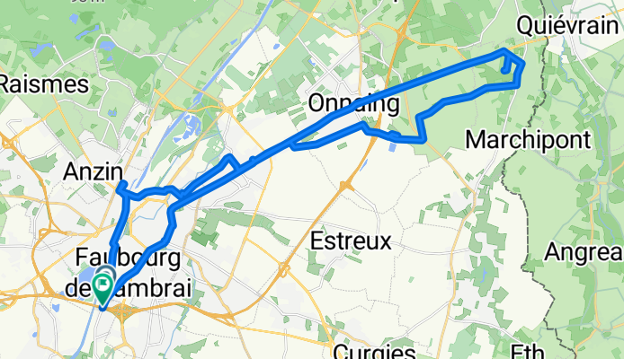
A 2, Trith-Saint-Léger à Rue Gustave Delory, Trith-Saint-Léger
A cycling route starting in La Sentinelle, Hauts-de-France, France.
Overview
About this route
- 2 h 25 min
- Duration
- 34.3 km
- Distance
- 128 m
- Ascent
- 119 m
- Descent
- 14.2 km/h
- Avg. speed
- 50 m
- Max. altitude

Route quality
Waytypes & surfaces along the route
Waytypes
Quiet road
10.6 km
(31 %)
Road
3.1 km
(9 %)
Surfaces
Paved
24 km
(70 %)
Asphalt
22.3 km
(65 %)
Concrete
1.7 km
(5 %)
Undefined
10.3 km
(30 %)
Continue with Bikemap
Use, edit, or download this cycling route
You would like to ride A 2, Trith-Saint-Léger à Rue Gustave Delory, Trith-Saint-Léger or customize it for your own trip? Here is what you can do with this Bikemap route:
Free features
- Save this route as favorite or in collections
- Copy & plan your own version of this route
- Sync your route with Garmin or Wahoo
Premium features
Free trial for 3 days, or one-time payment. More about Bikemap Premium.
- Navigate this route on iOS & Android
- Export a GPX / KML file of this route
- Create your custom printout (try it for free)
- Download this route for offline navigation
Discover more Premium features.
Get Bikemap PremiumFrom our community
Other popular routes starting in La Sentinelle
 A 2, Trith-Saint-Léger à Rue Gustave Delory, Trith-Saint-Léger
- Distance
- 34.3 km
- Ascent
- 128 m
- Descent
- 119 m
- Location
- La Sentinelle, Hauts-de-France, France
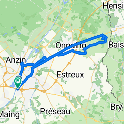
 24 04 2021
- Distance
- 39.3 km
- Ascent
- 215 m
- Descent
- 217 m
- Location
- La Sentinelle, Hauts-de-France, France
 92 ter Rue du Vert Gazon, Valenciennes à 212 Avenue Anatole France, Anzin
- Distance
- 5.6 km
- Ascent
- 38 m
- Descent
- 13 m
- Location
- La Sentinelle, Hauts-de-France, France
 De Rue Malplaquet 6, Valenciennes à Rue Malplaquet 12, Valenciennes
- Distance
- 29.8 km
- Ascent
- 360 m
- Descent
- 376 m
- Location
- La Sentinelle, Hauts-de-France, France
 20 km alentour Valenciennes
- Distance
- 20.8 km
- Ascent
- 141 m
- Descent
- 146 m
- Location
- La Sentinelle, Hauts-de-France, France
 Tour Trith 20 km
- Distance
- 18.7 km
- Ascent
- 149 m
- Descent
- 148 m
- Location
- La Sentinelle, Hauts-de-France, France
 Gilles Polomé Aviation
- Distance
- 6.9 km
- Ascent
- 17 m
- Descent
- 14 m
- Location
- La Sentinelle, Hauts-de-France, France
 11-07-2021
- Distance
- 35.9 km
- Ascent
- 74 m
- Descent
- 75 m
- Location
- La Sentinelle, Hauts-de-France, France
Open it in the app