

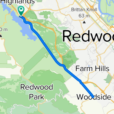
Canada Sprint
A cycling route starting in Highlands-Baywood Park, California, United States.
Overview
About this route
- -:--
- Duration
- 9 km
- Distance
- 134 m
- Ascent
- 78 m
- Descent
- ---
- Avg. speed
- ---
- Max. altitude
Route quality
Waytypes & surfaces along the route
Waytypes
Busy road
8.8 km
(98 %)
Road
0.1 km
(2 %)
Surfaces
Paved
7.8 km
(87 %)
Asphalt
7.8 km
(87 %)
Undefined
1.2 km
(13 %)
Continue with Bikemap
Use, edit, or download this cycling route
You would like to ride Canada Sprint or customize it for your own trip? Here is what you can do with this Bikemap route:
Free features
- Save this route as favorite or in collections
- Copy & plan your own version of this route
- Sync your route with Garmin or Wahoo
Premium features
Free trial for 3 days, or one-time payment. More about Bikemap Premium.
- Navigate this route on iOS & Android
- Export a GPX / KML file of this route
- Create your custom printout (try it for free)
- Download this route for offline navigation
Discover more Premium features.
Get Bikemap PremiumFrom our community
Other popular routes starting in Highlands-Baywood Park
 Belmont Woods Way, Belmont to Belmont Woods Way, Belmont
- Distance
- 12.7 km
- Ascent
- 279 m
- Descent
- 274 m
- Location
- Highlands-Baywood Park, California, United States
 36–40 Canada Rd, Redwood City to 2 Mount Vernon Ln, Atherton
- Distance
- 19.4 km
- Ascent
- 139 m
- Descent
- 222 m
- Location
- Highlands-Baywood Park, California, United States
 Skyline - Tunigas
- Distance
- 74.7 km
- Ascent
- 1,279 m
- Descent
- 1,275 m
- Location
- Highlands-Baywood Park, California, United States
 Belmont Woods Way, Belmont to Belmont Woods Way, Belmont
- Distance
- 19 km
- Ascent
- 515 m
- Descent
- 514 m
- Location
- Highlands-Baywood Park, California, United States
 Canada to woodside
- Distance
- 23.4 km
- Ascent
- 193 m
- Descent
- 189 m
- Location
- Highlands-Baywood Park, California, United States
 Can#ada up La Honda
- Distance
- 45 km
- Ascent
- 628 m
- Descent
- 639 m
- Location
- Highlands-Baywood Park, California, United States
 Canada Sprint
- Distance
- 9 km
- Ascent
- 134 m
- Descent
- 78 m
- Location
- Highlands-Baywood Park, California, United States
 Peninsula.1
- Distance
- 100.5 km
- Ascent
- 2,861 m
- Descent
- 2,852 m
- Location
- Highlands-Baywood Park, California, United States
Open it in the app