

Chemnitz Hbf -Meißen-DD Hbf
A cycling route starting in Chemnitz, Saxony, Germany.
Overview
About this route
Route ist für Cross- oder Mountainbike geeignet.
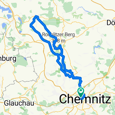
Von Chemnitz über Glösa ansteigend, nach Auerswalde über Waldsiedlung Oberlichtenau nach Sachsenburg zur Hängebrücke (die man zu Fuß überqueren muß) flach gerade und abfallend, ab Sachsenburg bis Kloster Altzella im Wechsel ansteigend und bergab, wobei bergab zum Schluß überwiegt. Im Kloster kann man eine Rast einlegen. Von hier gehts dann immer gerade flach bis leicht abfallend durch Nossen und entlang einer mäßig befahrenen Hauptstr. in das ruhigere Triebischtal und weiter zum Markt nach Meißen. Hier wieder Rast und dann auf der rechten Seite des Elbradweges nach Dresden zum Hbf. Dieser Radweg ist nicht ganz so dicht befahren wie der gegnüberliegende.
Züge fahren in Hainichen, Nossen und an den Zielen sowieso.
Alles in allem bei schönem Wetter eine sehr gute Strecke als Tagestour.
- -:--
- Duration
- 99.9 km
- Distance
- 310 m
- Ascent
- 504 m
- Descent
- ---
- Avg. speed
- ---
- Max. altitude
Route quality
Waytypes & surfaces along the route
Waytypes
Quiet road
28.5 km
(28 %)
Busy road
26.4 km
(26 %)
Surfaces
Paved
76.7 km
(77 %)
Unpaved
4.8 km
(5 %)
Asphalt
70.1 km
(70 %)
Gravel
3.3 km
(3 %)
Continue with Bikemap
Use, edit, or download this cycling route
You would like to ride Chemnitz Hbf -Meißen-DD Hbf or customize it for your own trip? Here is what you can do with this Bikemap route:
Free features
- Save this route as favorite or in collections
- Copy & plan your own version of this route
- Split it into stages to create a multi-day tour
- Sync your route with Garmin or Wahoo
Premium features
Free trial for 3 days, or one-time payment. More about Bikemap Premium.
- Navigate this route on iOS & Android
- Export a GPX / KML file of this route
- Create your custom printout (try it for free)
- Download this route for offline navigation
Discover more Premium features.
Get Bikemap PremiumFrom our community
Other popular routes starting in Chemnitz
 Zeisig-HELLYEAH-wald-1.0
- Distance
- 19.9 km
- Ascent
- 186 m
- Descent
- 186 m
- Location
- Chemnitz, Saxony, Germany
 Raben-Küch-Wald-Fetzt-Runde
- Distance
- 28.8 km
- Ascent
- 246 m
- Descent
- 254 m
- Location
- Chemnitz, Saxony, Germany
 Chemnitz Küchwald - Kriebstein und zurück
- Distance
- 71.5 km
- Ascent
- 567 m
- Descent
- 567 m
- Location
- Chemnitz, Saxony, Germany
 Goldner Hahn _ Wasserschloß
- Distance
- 34.3 km
- Ascent
- 670 m
- Descent
- 675 m
- Location
- Chemnitz, Saxony, Germany
 West- Nord- Runde (Grüna, Glöse, ...)
- Distance
- 49.8 km
- Ascent
- 339 m
- Descent
- 339 m
- Location
- Chemnitz, Saxony, Germany
 Zschopextreme
- Distance
- 47.7 km
- Ascent
- 675 m
- Descent
- 677 m
- Location
- Chemnitz, Saxony, Germany
 Chemnitz - Rochlitzer Berg - Bad Lausick - Chemnitz 2
- Distance
- 108.4 km
- Ascent
- 546 m
- Descent
- 543 m
- Location
- Chemnitz, Saxony, Germany
 Abendrunde I
- Distance
- 30.6 km
- Ascent
- 218 m
- Descent
- 218 m
- Location
- Chemnitz, Saxony, Germany
Open it in the app