
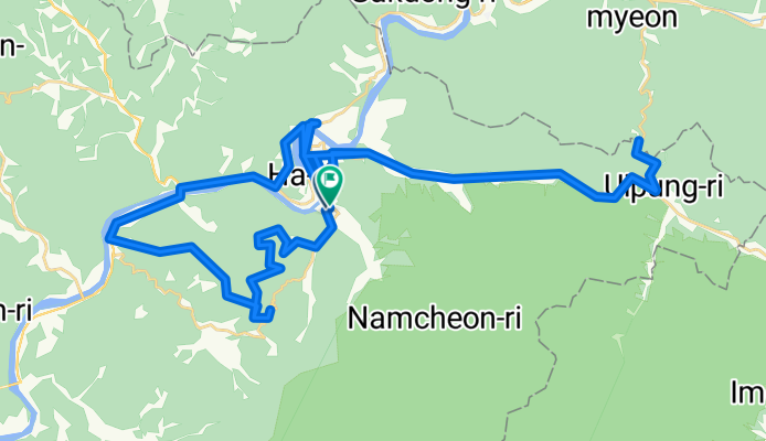
영춘면 ~ 김삿갓계곡
A cycling route starting in Neietsu, Gangwon-do, South Korea.
Overview
About this route
- 4 h 38 min
- Duration
- 66.4 km
- Distance
- 3,325 m
- Ascent
- 3,335 m
- Descent
- 14.3 km/h
- Avg. speed
- 682 m
- Max. altitude
Route quality
Waytypes & surfaces along the route
Waytypes
Track
11.9 km
(18 %)
Quiet road
11.3 km
(17 %)
Surfaces
Paved
46.4 km
(70 %)
Unpaved
10.6 km
(16 %)
Asphalt
45.1 km
(68 %)
Gravel
10.6 km
(16 %)
Continue with Bikemap
Use, edit, or download this cycling route
You would like to ride 영춘면 ~ 김삿갓계곡 or customize it for your own trip? Here is what you can do with this Bikemap route:
Free features
- Save this route as favorite or in collections
- Copy & plan your own version of this route
- Sync your route with Garmin or Wahoo
Premium features
Free trial for 3 days, or one-time payment. More about Bikemap Premium.
- Navigate this route on iOS & Android
- Export a GPX / KML file of this route
- Create your custom printout (try it for free)
- Download this route for offline navigation
Discover more Premium features.
Get Bikemap PremiumFrom our community
Other popular routes starting in Neietsu
 예미 ~ 강릉
- Distance
- 113.1 km
- Ascent
- 2,806 m
- Descent
- 3,233 m
- Location
- Neietsu, Gangwon-do, South Korea
 Yeongwol-eup, Yeongweol to Yeongwol-eup, Yeongweol
- Distance
- 61.6 km
- Ascent
- 0 m
- Descent
- 0 m
- Location
- Neietsu, Gangwon-do, South Korea
 Route to 영월읍 856-9, 영월군
- Distance
- 6.5 km
- Ascent
- 23 m
- Descent
- 26 m
- Location
- Neietsu, Gangwon-do, South Korea
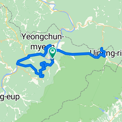 영춘면 ~ 김삿갓계곡
- Distance
- 66.4 km
- Ascent
- 3,325 m
- Descent
- 3,335 m
- Location
- Neietsu, Gangwon-do, South Korea
 영주-49저수령-82과게이재-98적성로고개-109제천 1880m
- Distance
- 108.8 km
- Ascent
- 2,398 m
- Descent
- 2,282 m
- Location
- Neietsu, Gangwon-do, South Korea
 영월읍, 영월군 to 단양읍, 단양군
- Distance
- 41.3 km
- Ascent
- 969 m
- Descent
- 1,007 m
- Location
- Neietsu, Gangwon-do, South Korea
 산동읍-수라리재-만항재-자미원-산동읍
- Distance
- 105.8 km
- Ascent
- 2,098 m
- Descent
- 2,098 m
- Location
- Neietsu, Gangwon-do, South Korea
 별마로-수라리재
- Distance
- 39.8 km
- Ascent
- 1,049 m
- Descent
- 693 m
- Location
- Neietsu, Gangwon-do, South Korea
Open it in the app